proposed coal ship anchorages off gabriola

You are correct, ziggy - paper charts ARE mandatory. It is also mandatory to keep those charts up-to-date. Any nav aids are just that - an "aid".

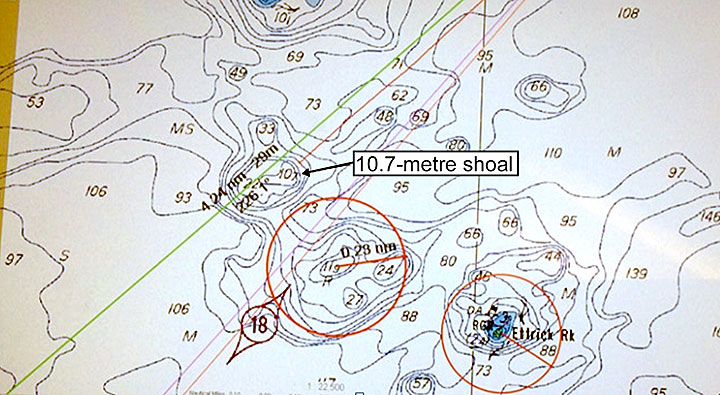
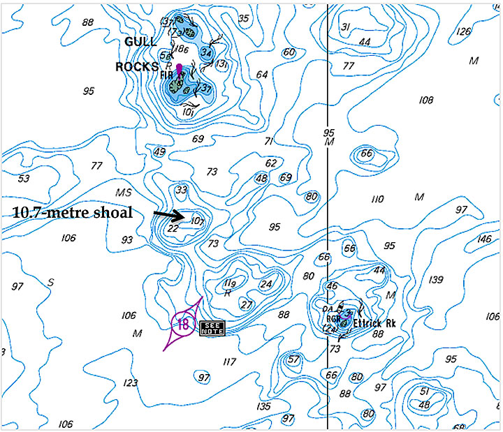
From the TSB link above that GLG provided it states: "The charted 10.7-metre shoal went undetected by the bridge team during the voyage planning process and during monitoring of the vessel's progress toward the anchorage. As a result, the vessel, with a draft of 13.3 m, ran aground when it passed over the charted shoal of 10.7 m."

they had a pilot onboard unfamiliar w the area directing the "bridge team". Not sure how he missed the rock...but he did.

Kinda supports what I was saying in post #26 about human error...
 
Last edited by a moderator:
Error for sure. However, on charts that 10.7 number is written on the chart as big 10 with a smaller 7 beside it. The depth is also printed over a depth contour line that kind of made it look like 107. There are some pretty drastic depth variances in the vicinity which make a depth of 107 not completely unbelievable. That and the last minute change of plans; from anchor to Rupert, then cancelled and back to anchor didn't help.... Not trying to defend, just saying. Pretty sure the pilotage made some risk assessments of the area with corrective actions... It was an unusual route to take.
 
Agreed on all TC.

Just 1 more point to make.

There are actually 3 "errors" here: Pilot, Skipper, Mate on Duty. ALL had responsibility to ensure the route was safe and check the chart. So what happened here wrt the "Bridge Team"?
 
Last edited by a moderator:
Error for sure. However, on charts that 10.7 number is written on the chart as big 10 with a smaller 7 beside it. The depth is also printed over a depth contour line that kind of made it look like 107. There are some pretty drastic depth variances in the vicinity which make a depth of 107 not completely unbelievable. That and the last minute change of plans; from anchor to Rupert, then cancelled and back to anchor didn't help.... Not trying to defend, just saying. Pretty sure the pilotage made some risk assessments of the area with corrective actions... It was an unusual route to take.

Where is this depth variance that makes a pinnacle look like a hole elsewhere on this chart? I do agree that the 10.7 is a nasty thing to put on that chart as we now can see what can happen. I don't think putting a "R" is going to help but I sure hope so.

m14p0150-figure-03.jpg


m14p0150-figure-01.jpg
 
Last edited by a moderator:
Don't agree with the paper chart comment. This from CHS site.

Most vessels of any kind in Canada have an obligation to carry and use official charts and publications and to keep them up to date. The chart carriage requirements are listed in the Charts and Nautical Publications Regulations, 1995 of the Canada Shipping Act.

CHS paper charts meet the requirements of the chart carriage regulations. CHS digital charts meet the requirements of the chart carriage regulations under certain circumstances. CHS Electronic Navigational Charts (ENCs) meet the requirements provided they are used with an Electronic Chart Display and Information System (ECDIS). CHS raster charts meet the requirements only if paper charts are carried and used as a backup.

For further information on which charts meet the official requirements, please see our CHS Official Products and CHS Licensed Manufacturers.

You are right about paper charts and the law. That was not my point. My point was that our world class rules are for less technology then what I have in my recreational fishing boat for the last 10 years. But all is not lost because of this remark in the website from this accident.

International Maritime Organization (IMO) Resolution MSC.282(86) requires cargo ships, other than tankers, of 20 000 in gross tonnage and upwards but less than 50 000 in gross tonnage constructed before 01 July 2013 and engaged on international voyages to be fitted with an electronic chart display and information system (ECDIS) not later than its first survey on or after 01 July 2017.

Speaks to our world class does it.....

So what has the ship in question done to remedy the error going forward and why the hell did they not do this 10 years ago?

Iino Marine Services Co. Ltd.

In November 2014, the management company responsible for the Amakusa Island installed an electronic chart display and information system (ECDIS) on board. The company also initiated training for the crew in various aspects of human performance.

I see .... they are world class after the horse has left the barn.
 
Last edited by a moderator:
They had a pilot onboard unfamiliar w the area directing the "bridge team". Not sure how he missed the rock...but he did.


And that is my point also... How the hell do we have for a world class system if we have a pilot that is unfamiliar with the area? Correct me if i'm wrong but should the first rule of a pilot be to know the area. After all isn't that what a pilot is for. If the system puts a man in that doesn't know the area, then there is something wrong with the system. Were not world class if we make such a basic error.
 
You are right about paper charts and the law. That was not my point. My point was that our world class rules are for less technology then what I have in my recreational fishing boat for the last 10 years. But all is not lost because of this remark in the website from this accident.


Speaks to our world class does it.....

So what has the ship in question done to remedy the error going forward and why the hell did they not do this 10 years ago?


I see .... they are world class after the horse has left the barn.

So after all is said and done you don't really have a problem with properly ammended and up to date paper charts being used? In this case as a backup. I guess your original statement on them was confusing. As an aside when was the last update done to your electronic system?
 
So after all is said and done you don't really have a problem with properly ammended and up to date paper charts being used? In this case as a backup. I guess your original statement on them was confusing. As an aside when was the last update done to your electronic system?

Yes I have no problem with them using paper charts as a backup but clearly we have the technology for ships of this size to navigate with far better electronic systems. Perhaps with the systems that were described in that webpage the alarms would have gone off to tell them the had made a mistake. Now that would be world class. Japan is not a third world country that has an excuse not to have the latest tech on their ships. This is a case of being to cheap to give their crews the correct tools. And Canada not insisting that they meet a minimum standard, after all it is 2015 and not 1940.

As for my e-charts.... yup mine are old (2010) but the paper charts are older. I just looked at new (2014) paper chart that I have for Nootka and it has not been updated since 2009. If you have a new chart go look at when it's last update was. Seems to me most of the charts I would use are all old data. That's the thing... they don't update very often but I'm a rec fisherman and I don't make my living on the sea where having the correct tools (electronics) for the job is critical to life and limb.
 
Paper chart updates are available as promulgated through Notice to Mariners. You are expected to do your own updates if you are a professional mariner. Like most I have no problem with electronic aids, however there is nothing wrong with using them in conjunction with a paper chart. I would not be surprised to discover that the reliance on alarms available on electronic chartplotters partially contributed. Had the Pilot, Master and Mate had a quick huddle around the chart observed the plotted track, I think one might have noticed the pinnacle. I'm all for technology, but you need to be able to read a chart IMO and be aware of the hazards before you trigger an alarm.
 
The job of keeping your paper charts current is up to you GLG, by making corrections that come out monthly in Notice to Mariners. Then you list the update in the bottom left corner of the chart.

Ecdis just shows the ship's position on the information gleaned from a paper chart. Now you're relying on a GPS signal to confirm your position instead of using it as a tool in conjunction with solid navigating practices which DON'T include relying on GPS.

The nearest depth over 100 meters can be found 0.23 miles SW of the charted rock on the chart you posted. It would take the average ship running at dead slow ahead Less than 5 minutes to travel 2.3 cables. There is a depth of 100M in every direction save North within a Mile. That's not in the vicinity?

As for the pilot being unfamiliar with the area, he was unfamiliar with the area of that rock, after having spent his marine career in the Prince Rupert area before becoming a respected pilot.

It was a terrible mistake to be sure, but one can't jump to conclusions without knowing the circumstances under which it took place.
 
Last edited by a moderator:
Just to be clear wrt the "Law" - as far as I understand it - all shipping over 100T have to carry and update charts:

http://laws-lois.justice.gc.ca/eng/regulations/SOR-95-149/page-2.html#h-6
"CARRIAGE OF CHARTS, DOCUMENTS AND PUBLICATIONS

4. (1) Subject to subsection (2), the master and owner of every ship shall have on board, in respect of each area in which the ship is to be navigated, the most recent editions of the charts, documents and publications that are required to be used under sections 5 and 6.

(2) The master and owner of a ship of less than 100 tons are not required to have on board the charts, documents and publications referred to in subsection (1) if the person in charge of navigation has sufficient knowledge of the following information, such that safe and efficient navigation in the area where the ship is to be navigated is not compromised:

(a) the location and character of charted
(i) shipping routes,
(ii) lights, buoys and marks, and
(iii) navigational hazards; and
(b) the prevailing navigational conditions, taking into account such factors as tides, currents, ice and weather patterns.
"

http://laws-lois.justice.gc.ca/eng/regulations/C.R.C.,_c._1416/page-3.html#h-7
"7. Every vessel shall navigate with particular caution where navigation may be difficult or hazardous and, for that purpose, shall comply with any instructions and directions contained in Notices to Mariners or Notices to Shipping that are issued as a result of circumstances such as

(a) unusual maritime conditions;
(b) the undertaking of marine or engineering works;
(c) casualties to a vessel or aid to navigation; or
(d) changes to hydrographic information.
"

http://laws-lois.justice.gc.ca/eng/regulations/SOR-95-149/page-4.html#h-9
"7. The master of a ship shall ensure that the charts, documents and publications required by these Regulations are, before being used for navigation, correct and up-to-date, based on information that is contained in the Notices to Mariners, Notices to Shipping or radio navigational warnings."

This is where you do that updating:
http://www.notmar.gc.ca/go.php?doc=eng/index
 
Last edited by a moderator:
Paper chart updates are available as promulgated through Notice to Mariners. You are expected to do your own updates if you are a professional mariner. Like most I have no problem with electronic aids, however there is nothing wrong with using them in conjunction with a paper chart. I would not be surprised to discover that the reliance on alarms available on electronic chartplotters partially contributed. Had the Pilot, Master and Mate had a quick huddle around the chart observed the plotted track, I think one might have noticed the pinnacle. I'm all for technology, but you need to be able to read a chart IMO and be aware of the hazards before you trigger an alarm.

This is from the accident report.
http://www.tsb.gc.ca/eng/rapports-reports/marine/2014/M14P0150/M14P0150.asp

The bridge is equipped with the required navigational equipment, including an automatic identification system (AIS), 2 radars (fitted with automatic radar plotting aid capability), a GPS (global positioning system), and an echo sounder with its transducer located aft. The steering stand is located on the centreline of the vessel. The vessel is also fitted with a voyage data recorder. At the time of the occurrence, the vessel was not fitted with an electronic chart display and information system (ECDIS)

The vessel was navigating with paper charts. Yes they had a gps but it sounds like it just gave lat and long. You would need to plot the lat and long on the paper chart.

The pilot had a nav computer with 2 kinds of maps, raster and vector.

After boarding, the pilot set up his portable pilotage unit (PPU) with a raster chart for the area, on which he had prepared the passage plan from the berth to the pilot station. The vessel's navigation officer had also prepared an outbound voyage plan, on paper chart No. 4936, published by the United Kingdom Hydrographic Office (UKHO)

Having set up the PPU using a raster chart with a dynamic range and bearing line (DRBL), the pilot was able to monitor the vessel's speed over ground (SOG) and time of arrival at the anchorage. Once on DRBL, the pilot set the PPU to follow‑up mode, which displayed the vessel as a stationary icon on the screen while the chart scrolled beneath it.

[h=3]Portable pilotage unit[/h]The PPA provides each pilot of the BCCP with a PPU, a portable electronic device that allows the pilot to use electronic charts to assist in the pilotage of vessels. The PPA also provides pilots with an initial 5-day PPU training and 2.5-day refresher training. Neither the BCCP nor the PPA requires pilots to use the software in a particular way, nor does either organization require passages to be planned or a vessel's track to be recorded on the PPU.
The PPU gives a pilot the option of selecting either a vector or a raster navigation chart. A vector navigation chart is an electronic navigational chart (ENC) that is displayed using an electronic charting system (ECS) such as an ECDIS. In addition to providing the vessel's real-time position, the ENC can be programmed to take into account the vessel's particular characteristics, and specific weather and marine traffic conditions. An ENC programmed with these parameters can produce visual and audible alarms to warn of dangers. This allows a user to set alarms, including an alarm to indicate an insufficient underwater clearance during the planning or execution of the voyage. Additionally, the user can adjust the type and level of detail being displayed on an ENC (e.g., the ENC is capable of showing depth contours with associated text suppressed). An ENC also allows the user to zoom in on the chart to show denser data.


A raster navigational chart is essentially a paper navigational chart displayed in an electronic format. It does not have any of the programmable features associated with a vector navigational chart. The safety warnings on raster charts are the same as those that appear on the paper chart itself. Raster charts do not have the capability to show denser data when zoomed in.
The pilot's PPU had both the vector and the raster functionality; however, on the occurrence voyage, the pilot had selected a raster chart to emulate the vessel's paper chart.

Although the pilot was monitoring the vessel's progress on his portable pilotage unit (PPU), the use of a raster chart precluded available route planning and monitoring features that can assist in the detection of known hazards. The raster chart did not allow for an automated depth alarm to indicate insufficient underkeel clearance. The vessel was fitted with a depth sounder, but the transducer was located aft. Even if it had been fitted forward, it is unlikely that it would have prevented the grounding given the vessel's speed and momentum at the time.
The charted 10.7-metre shoal went undetected by the bridge team during the voyage planning process and during monitoring of the vessel's progress toward the anchorage. As a result, the vessel, with a draft of 13.3 m, ran aground when it passed over the charted shoal of 10.7 m.

[h=3]Findings as to causes and contributing factors[/h]
  1. The vessel's destination unexpectedly changed upon departure, and the new route passed in proximity to a charted 10.7-metre shoal.
  2. The charted shoal was not detected by the bridge team either while planning the revised route or during monitoring of the vessel's progress.
  3. The pilot's portable pilotage unit was not configured with all available route planning and monitoring features to assist in the detection of known hazards.
  4. The vessel, with a draft of 13.3 m, ran aground when it passed over a charted shoal of 10.7 m.

I personal think that the pilot was not comfortable with the computer set in Vector mode. That would be a training issue.
 
I personal think that the pilot was not comfortable with the computer set in Vector mode. That would be a training issue.[/QUOTE]

Just stop GLG. You don't know what you're talking about.
 
The job of keeping your paper charts current is up to you GLG, by making corrections that come out monthly in Notice to Mariners. Then you list the update in the bottom left corner of the chart.

Ecdis just shows the ship's position on the information gleaned from a paper chart. Now you're relying on a GPS signal to confirm your position instead of using it as a tool in conjunction with solid navigating practices which DON'T include relying on GPS.

The nearest depth over 100 meters can be found 0.23 miles SW of the charted rock on the chart you posted. It would take the average ship running at dead slow ahead Less than 5 minutes to travel 2.3 cables. There is a depth of 100M in every direction save North within a Mile. That's not in the vicinity?

As for the pilot being unfamiliar with the area, he was unfamiliar with the area of that rock, after having spent his marine career in the Prince Rupert area before becoming a respected pilot.

It was a terrible mistake to be sure, but one can't jump to conclusions without knowing the circumstances under which it took place.

The pilot should have check his computer to see what the depths were on his route. If someone hands me a paper chart with a route marked over that kind of contour lines.... well I think I would have been more cautious.

Your right about the me not knowing everything as to what was happening at the time and I guess we should give him some benefit of the doubt. What I do think is that the pilot system failed him in a number of ways. I'm glad that changes have been made like these.

From the accident report
http://www.tsb.gc.ca/eng/rapports-reports/marine/2014/M14P0150/M14P0150.asp

[h=4]British Columbia Coast Pilots Ltd.[/h]The British Columbia Coast Pilots Ltd. (BCCP) has completed safety corridors for all areas of the coast, excluding Haida Gwaii. The corridors for Prince Rupert, British Columbia, were finalized in August 2014, and the central coast to Prince Rupert was finalized in February 2015. The corridors represent areas where it is deemed safe to navigate with consideration to factors such as current, weather, traffic, and vessel size. The area around Gull Rocks, British Columbia, is outside of a safety corridor. All safety corridors data are distributed via a cloud service and installed on each pilot's portable pilotage unit.
On 11 June 2015, the BCCP and the Pacific Pilotage Authority (PPA) reached an agreement to

  • require all pilots, regardless of years of service, to undergo mandatory assessments, not less than once every 5 years;
  • improve upon the currency program to better monitor individual pilot's assignment history and identify any lapses in currency; and
  • create additional opportunities for pilots to obtain recent experience for the areas in question.

I would have added more training on the nav computer and the use of vector charts with it's added safety features.

I have a lot of respect for the people that are professional mariners.
My apologies if it seems I was disrespectful.

I wanted point out that our so called world class system is not what we are being told by the spinners from the Feds.
 
GLG said:
I personal think that the pilot was not comfortable with the computer set in Vector mode. That would be a training issue.

tugcaptian said:
Just stop GLG. You don't know what you're talking about.

I'm open to learning from your experience as I'm only reading the report and trying to understand it.
Again I'm not trying to be disrespectful.
 
Last edited by a moderator:
...There are actually 3 "errors" here: Pilot, Skipper, Mate on Duty. ALL had responsibility to ensure the route was safe and check the chart. So what happened here wrt the "Bridge Team"?
...Had the Pilot, Master and Mate had a quick huddle around the chart observed the plotted track, I think one might have noticed the pinnacle...
THANK YOU ZIGGY!

So - why aren't we discussing this lapse in bridge oversight?

What happened on the bridge on the Queen of the North?

Seeing common issues? That's the real "terrible mistake" to me.

Ziggy already hit the nail on the head - but I noticed that you have (so far) avoided discussing this TC. I'd like to hear (read) your thoughts...
 
Last edited by a moderator:
I think that unfortunately, SOME foreign crews mentally "check out" when the pilot comes aboard, assuming he has it all in hand (they usually do!).
The Captain may not have been on the bridge, it could have been an officer and a helmsman. Perhaps the officer (or captain) came from a culture where questioning the pilot was uncomfortable, I don't know what went wrong there. Doesn't sound like Transport Canada does either as they didn't cite a cause for the bridge team break down.
Transport Canada also didn't mention how during their quick huddle over the chart when the plan changed, a quick point at that spot could have indeed looked to them like 107m and not 10.7m as we discussed earlier. Every other mariner I talked about it with did. It's only 0.06M from the nearest 75m patch, and 0.23M from the next 100m patch. For those who think in imperial measures, the depths around that spot go from 250ft deep (to the SW) to 30ft deep in less than a ship's length, and then to a depth of 350ft about 400 yards to the SW . Now we look at it with investigative eyes it seems obvious, but with a quick look at that potentially confusing printing of that depth sounding that GLG posted for us, it's not too far fetched to see how that could happen.
I will admit to GLG that the TC investigation's point (that he reiterated) about having the vector charts PPU depth alarm set for a ship with a 13m draft may have helped avoid that incident, but I still maintain that GLG's suggestion that the pilot was uncomfortable with vector charts or lacked training is utter rubbish. (P.S. I didn't take it as disrespectful GLG, I sometimes get too passionately argumentative about topics close to my heart sorry)
I use vector and raster electronic charts as well, and I switch between them with one click for the preferred view. I too have switched to Raster charts when in areas of drastic depth changes, due to the clutter on the vector chart, especially when viewing in night time colors. Yes the layering can be reduced, but even with training the time it takes to change the layering settings that you were happy with 2 Miles ago to what you need now, could be considered to be too much time taken away from looking out the window. Yes you might have missed a rock but now you've run over a fishing boat?! (just kidding but you get the point)
Yes, I agree with the findings of the investigation that were brought up. Clearly the bridge team under the Captains direction failed to focus properly (perhaps with the ship's officer on cruise control) and support the pilot as he conned the vessel. Clearly the pilot was also in error by taking an unusual route without fully investigating the charted depths. And, perhaps more equipment used properly may have helped.
It sucks to make mistakes like that when there will be so much public scrutiny on your actions later. You can sometimes get away with a mistake out here, but 2 mistakes turn into 3 and it snowballs from there until you pay.
I don't like the comparison to the Queen of the North made by aqua. Yes they both hit rocks. Yes both bridge teams failed, but the ferry was gross negligence, and I believe the Coal ship hitting that rock was more of a series of mistakes. Perhaps it just seems like I'm splitting hairs to some of you?
Now I'm laughing at myself for earlier suggesting that those discussing the environment on a thread discussing a proposed anchorage site should start another thread, and now here I am on another wild offshoot....
I DO believe our system of pilotage is world class. A look at the complexity of our coast and our pilots safety record speaks for itself. Its public record, you can look it up and compare it to other places in the world yourself.
 
Last edited by a moderator:
Thanks for tackling the thorny topic with honesty and openness, TC.

I agree (again) with all of your points - and while I am at it - let me try to clarify my intent.

My intent is not in any way to denigrate the marine profession or any Mariners. My intent is to point out that (unfortunately) human error is often a large part of any marine incident - as I posted earlier on this thread. Again, to reiterate - that is why we have the TSB - to help understand what went wrong - so we can learn from these mistakes.

The biggest difference (to me) wrt marine incidents - is the mass and momentum involved.

In an office - most desks weigh a couple hundred pounds - and the cleaning lady usually doesn't even move that. A paper cut is generally the most traumatic incident.

On the water - with shipping - we enter a whole new realm.

Most ships/boats run from a few Tons to a few hundred thousand tons. Most vessels navigate at speeds of 7-25 knots. You already know this.

Weight at speed causes momentum - whether the weight is dangling over your head - or in the main tanks of a VLCC coming down Douglas Channel and heading out through Whales Channel (i.e. the Enbridge scenario). When momentum from a large vessel happens - it is more than a paper cut.

I agree it is often the numerous smaller mistakes that add up to a larger mistake. How do these small mistakes get started?

Well treating each incident as a non-related one off that will never happen again is not appropriate risk management.

It is a culture of safety - or rather the lack thereof - that contributes to having those numerous small mistakes turn into a big one.

Simply stating - we have the best "X" in the world avoids that sometimes uncomfortable conversation that really needs to happen.

The Queen of the North was gross negligence - as you stated. How did that gross negligence come to be?

Lack of a culture of safety onboard a boat...

This stems from lack of direction and guidance from the Skipper and above. It happens (unfortunately).

Yes, there are also sometimes compounding factors like lack of maintenance, equipment failures, severe weather and the like - this is where the TSB does a good job in pointing these failures out - but the TSB is not a "blame setting" process wrt personnel. And that is ok.

However - where do we get to understand things enough so that we can correct things like poor bridge deportment/oversight, poor communication, and lack of leadership on the culture of safety?

This is where there are obvious (to me) similarities between this coal boat, and the Queen of the North. There are many, many other examples of this - unfortunately - in both big and small boats.

How can we begin to understand this enough so that we can help correct this issue w/o getting people defensive that the intent is instead to besmirch the profession of Mariners? There doesn't seem to be the same defensiveness when one attends a MED course? Why can't we have that same conversation here?

Maybe we are - now...
 
Last edited by a moderator:
I also agree with your comments Aqua. I have no problem discussing these things and trying to be open minded, even though I fail sometimes by being defensive. I have never believed anyone commenting on here is trying to "besmirch" the maritime profession.
 
Thanks, TC. I think that I and the other readers/posters/lurkers on this thread appreciate you sharing your insights and experiences - and your honesty.

I like the direction the marine industry has gone wrt analysing marine incidents wrt the TSB over the past few decades. I like the focus (where/when it happens) on encouraging a culture of safety. I think that is often the goal of many professional marine work environments. I think there definitely been some rather large improvements wrt the culture of safety, and the associated safety and navigational equipment over the past 30+ years. I think things are definitely improving.

But this is not a "normal" work environment (i.e. the "paper cut" post)...

It's just that when things go wrong - they often go wrong in a spectacularly large way due to weight/size/momentum effects. The margins of error are small (but do exist) - it's the consequences/effects that are often gigantic.

So - staying drug and alcohol free while on watch - having an open, respectful, professional deportment/communications - while providing support through an understood and utilized chain-of-command and clearly articulated and understood responsibilities; including checks and balances of both legislated and non-legislated policies that are developed through an honest and open appraisal of "mistakes" - all contributes to developing and maintaining this "culture of safety".

Unfortunately, not every marine work environment is able to understand and develop this support. Just like other work environments - there are "good" and "poor" skippers and crewmembers- "excellent" and "not-so-excellent" companies and outfits. Little mistakes often turn into big ones - as you pointed-out. The best way to avoid big mistakes is - to avoid the little one first. The way to do that is to remain on your toes, and learn from all the mistakes - which requires an honest risk assessment appraisal - all the time.

'nuff said...

Thanks again for sharing your experience.
 
Last edited by a moderator:
Back
Top