Navionics question

I can see people wanting a warning if it’s for a specific area and unique to a small section. My concern is that for example, in Juan de Fuca the rule is consistent throughout the area. Perhaps a warning printed in an area of the screen would make sense? It’s IMO needless clutter that can easily be mistaken for other warnings.This is the message I’m complaining about.
‘Information: Keep at least 400 m from all Killer Whales, for more information contact local authorities’
I don't disagree, but if they are going to put restrictions on large area's that we transit, and apply fines to those that don't comply, we need to have these area's readily available.

A picture like this, with no defined Lat/Long boundaries does not cut it.


Attachments

  • slow zones.pdf
    2.8 MB · Views: 11
I installed Navionics on my cell phone and tablet years ago and just chose to not do any of the updates etc Now my tablet and phone applications are useless as they don’t show any detail. If I pay the annual fee to get it back up and running do I have to do this every year to keep it usable? Can I just pay the annual fee this year and then leave it alone like I did for years?

I already have 3 boats with Lowrance units and chips that I bought and am just wondering how much more I need to give this company. They are now a silent partner in my fishing trips‍.
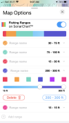
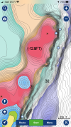
I find the fishing ranges that you can set to be the best feature that you have to pay for and worth the 38 per year (considering what I spend annually on backup flashers). Sets a pink band on the contours you want to fish so you can keep your gear close to structure when that is needed
 
I find the fishing ranges that you can set to be the best feature that you have to pay for and worth the 38 per year (considering what I spend annually on backup flashers). Sets a pink band on the contours you want to fish so you can keep your gear close to structure when that is needed
Huh, I've never used that. Would be a great thing for rookie drivers.
 
I just renewed my iPad Navionics a few days ago. It expired May 2021. But I had full functionality after it expired including its most awesome features:
- auto-routing (Super simple to use)
- detailed bottom contours
- RCAs
- Fishing ranges

All I lost was Satellite overlay which is of no use when on the water. I just updated as we are off on Friday to Port Hardy, Hakai, Milbanke, Shearwater for 2 weeks :)) Didn’t get anything useful except a few little changes/updates on bottom contour?)

We set up the Fishing ranges traffic light style - green, orange, red. Yes it’s great for a new driver. ‘Stay in the green’ . It’s also great for me as when I’m fishing I’m frequently in one of three fishing states of mind; tired, distracted, mildly intoxicated. (…sometimes I can achieve the trifecta ‍)

The purple is set 200-300’ and pops up bottom fishing spots like a beacon.
This feature only showed up about 2020 and is worth an upgrade if you don’t have it yet.
52CA20B4-5765-43B4-A3A9-110418F76BED.png4DBA28BA-4CA0-4752-AA8C-964FB3029BDA.png
 
Last edited:
Sorry to hijack but ... My phone app shows RCA's but my onboard unit does not. Can I update the Navionics card onboard or do I have to buy an new updated card?
 
Sorry to hijack but ... My phone app shows RCA's but my onboard unit does not. Can I update the Navionics card onboard or do I have to buy an new updated card?
It’s a sd card so you plug it into your computer to update the card. Don’t need to buy a new one
 
But do you need to buy a year's worth something to get the updates?
Yea you would. I usually buy a year, set a reminder in my phone to update right before it’s gonna run out, and then update at the end . Then I wait a year or two or whenever I feel the need to update again and buy another year. No real need to update constantly
 
I spent weeks with Navionics and various DFO offices to get those red dotted lines put on the charts. They are still not on the simcard for my Simrad, but they are on the app. Beside my 12 inch EVO we have a 13 inch ipad that runs the app. There are aspects of the app that are better than the chart plotter.

I agree that having red dotted lines all over that place is a really poor way of showing things on the chart. In this day and age it should be easy to show restricted area's or DFO closures by using colored shaded area's or similar. Navionics does updates all the time and say they work with DFO and would like to make timely changes. DFO is the problem - Surprise!! When I first started trying to get info from DFO they kept pushing me to the head office in Quebec, they didn't know where Juan deFuca strait was, one didn't know what an Orca was.

Bottom line is: do you play by the rules? ( not you specifically) If all we had to do was glance at our charts that showed all updated info it would be very easy to know what's up.

I transited the the orca slow zones on a Barkley trip first week of June, one of the zones was still not on the chart so I faked it. It was more efficient to go around these zones than to cut my speed by more than half and spend hours plodding through the zones.

While in Barkley we could hear DFO/Coast guard barking at people about the restriction on channel 16. I don't know if there were any fines.

Having DFO/Coastguard chasing people around offshore is a complete waste of resources. Just fix the damn charts and we would all know what's expected of us.

I worked with Brad Beaith in Pacific Region DFO to get the RCA data to Navionics in 2017. Both parties seemed entirely willing, but hadn't ever talked to each other. I found Brad to be responsive, and Navionics added the lines within weeks.

If we collectively think there's better ways to display the data, we should try. It would probably come better from a body like SFBC than from individual users [who may have a bunch of opinions]. My two cents.
 
Back
Top