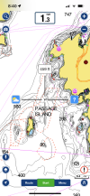
I spent weeks with Navionics and various DFO offices to get those red dotted lines put on the charts. They are still not on the simcard for my Simrad, but they are on the app. Beside my 12 inch EVO we have a 13 inch ipad that runs the app. There are aspects of the app that are better than the chart plotter.
I agree that having red dotted lines all over that place is a really poor way of showing things on the chart. In this day and age it should be easy to show restricted area's or DFO closures by using colored shaded area's or similar. Navionics does updates all the time and say they work with DFO and would like to make timely changes. DFO is the problem - Surprise!! When I first started trying to get info from DFO they kept pushing me to the head office in Quebec, they didn't know where Juan deFuca strait was, one didn't know what an Orca was.
Bottom line is: do you play by the rules? ( not you specifically) If all we had to do was glance at our charts that showed all updated info it would be very easy to know what's up.
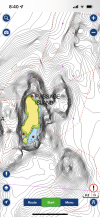
I transited the the orca slow zones on a Barkley trip first week of June, one of the zones was still not on the chart so I faked it. It was more efficient to go around these zones than to cut my speed by more than half and spend hours plodding through the zones.
While in Barkley we could hear DFO/Coast guard barking at people about the restriction on channel 16. I don't know if there were any fines.
Having DFO/Coastguard chasing people around offshore is a complete waste of resources. Just fix the damn charts and we would all know what's expected of us.