GLG
Well-Known Member
Please get your facts right.
El Niño Conditions
El Niño conditions are present in the equatorial Pacific Ocean, and are expected to persist through at least the end of the calendar year. All 4 Niño indexing regions

have had warm weekly sea-surface temperature (SST) departures from normal exceeding 1 degree Celsius, with the anomalies in the far eastern equatorial Pacific exceeding 2 degrees Celsius. Average over the last month, SSTs are warmer than normal across the entire Pacific as well. The "El Niño Advisory" that was released on March 5 is still in effect. Model predictions are now showing very high chances that the El Niño will persist through the calendar year and into next winter. Chances that the El Niño will persist through spring and summer exceed 90% with chances exceeding 80% that it will last through the winter of 2015-16.
What does this mean for Washington in the coming months?
The CPC three-class July-August-September (JAS) temperature outlook has increased chances of above normal temperatures for the entire state, with chances of warmer than normal temperatures highest in the western half of the state. For JAS precipitation, there are equal chances of below, equal to, or above normalprecipitation for the entire state.
The outlook for August-September-October (ASO) is also calling for increased chances of above normal temperatures statewide. As we approach fall, the precipitation outlook is calling for drier than normal conditions for nearly the entire state. An area in eastern WA (including Pullman, Walla Walla, and Spokane) has equal chances of below, equal to, or above normal precipitation for ASO.
Last Updated: 6/18/2015
Let's not forget the Blob as well, but you do know when that started, right?
Guess that might have an effect on this years weather.
So show us a map of the historical weather of B.C. As that is what this discussion is about.
I think you have misunderstood what I meant.... I might not have been clear. I should have said in post #98
"This could have something to do with the river temps. And to think, no El Niño effect yet... that comes next year."
I'm fully aware that we a now in El Niño and have been for several months.
http://www.cpc.ncep.noaa.gov/products/analysis_monitoring/enso_advisory/ensodisc.html

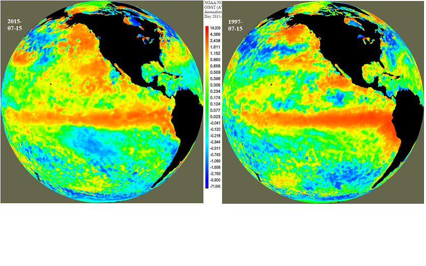
I don't know where you got your info from (you gave us no link) but I prefer to get mine from this source, I think we can both agree that is a good place to start. As you can see from the picture above the El Niño is off of South America and will start to effect us in the fall. The weather we are seeing now is from the BLOB and yes I do know when that started.
This is a helpful picture of what is going on. The top one is surface temperature and the bottom on is the difference from normal.
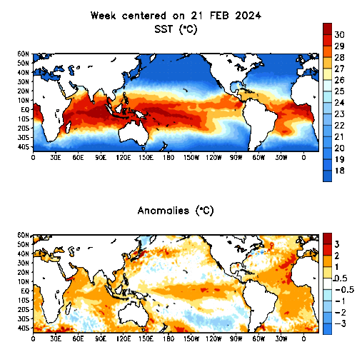
As you can see El Niño is building on the equator and will effect us later in the year. That's why I say it's not good for next years sockeye run. The BLOB is effecting us now. Hope this clears up our misunderstanding.
Last edited by a moderator: