
I saw that .Where is the tango 10 light buoy and the northern tip of lulu island on that map?
- Home
- Forums
- Sport Fishing BC Forums
- Saltwater Fishing Forum
- Archived Saltwater Fishing Reports
- 2017 Saltwater Fishing Reports
You are using an out of date browser. It may not display this or other websites correctly.
You should upgrade or use an alternative browser.
You should upgrade or use an alternative browser.
2017 OFFISHALL Vancouver-Howe Sound-Sechelt Reports Thread
- Thread starter fishin_magician
- Start date
cohojohnny
Active Member
This has the GPS coordinates of the waypoints DFO uses:
http://laws-lois.justice.gc.ca/eng/regulations/SOR-2007-77/page-3.html#h-7
http://laws-lois.justice.gc.ca/eng/regulations/SOR-2007-77/page-3.html#h-7
This has the GPS coordinates of the waypoints DFO uses:
http://laws-lois.justice.gc.ca/eng/regulations/SOR-2007-77/page-3.html#h-7
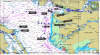
Thank you for the info guys but your honour (hypothetical). On the map provided by the department of fisheries I cannot locate a line from Gower Point to the Tango 10 light Buoy, then to the northern tip of Lulu Island. Your honour please show me on the this map provided the area in question. I don't own a device that shows coordinates. DFO If you want people to follow your f&$cking rules at least display them in a way that is SIMPLE and CLEAR. If I get a coho which is probably unlikely the fricken thing is going to be bonked and brought home for dinner because these boundaries, coordinates f#$cking waypoints are too complex and confusing for some of us. A simple fu@#g MAP with labelling T10 to the North tip of lulu f##$$g island would be extremely helpful ( I have lived here all my life ) I know Vancouver, Richmond, UBC, North Arm, South Arm. wreck f@$g beach but I have not knowingly been to Lulu Island. So from what I have gathered here is that the tango 10 light buoy is between the North and South arm. Okay I got it. Now where is the Northern tip of Lulu Island?
Last edited:
Silver Tip
Member
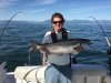
Landed this nice White Chinook this afternoon at high slack off of the North Arm...standard anchovy set up at 60' in 100' of water...beauty of a day out there today... 
cohojohnny
Active Member
49°23.021′N 123°32.166′W [Gower Point],
49°06.932′N 123°09.355′W [Lulu Island],
49 10 59.4 123 17 46.7 [T10]
Gower point is Gibsons (NW corner of area 29-3) so approximately north of T10 you're ok.
49°06.932′N 123°09.355′W [Lulu Island],
49 10 59.4 123 17 46.7 [T10]
Gower point is Gibsons (NW corner of area 29-3) so approximately north of T10 you're ok.
wet_coast_kid
Member
North Arm:: landed 1 chinook late morning just starting out, ~60 in 100ft. No other bites through the day. Was out to 4. Oh, and 1 crab lol. Lost a ball and broke my down rigger cable on some crater of a crab trap.
Tightlines22
Well-Known Member
 At Sandheads this afternoon. Was a nice calm outing. Thought we had a Spring on.
Nice clean doggy!View attachment 35319 At Sandheads this afternoon. Was a nice calm outing. Thought we had a Spring on.
")
49°23.021′N 123°32.166′W [Gower Point],
49°06.932′N 123°09.355′W [Lulu Island],
49 10 59.4 123 17 46.7 [T10]
Gower point is Gibsons (NW corner of area 29-3) so approximately north of T10 you're ok.
Are you sure that is the coordinates for the t10 and not the QA?49°23.021′N 123°32.166′W [Gower Point],
49°06.932′N 123°09.355′W [Lulu Island],
49 10 59.4 123 17 46.7 [T10]
Gower point is Gibsons (NW corner of area 29-3) so approximately north of T10 you're ok.


Jimfish
Member
Nice silverbrightView attachment 35319 At Sandheads this afternoon. Was a nice calm outing. Thought we had a Spring on.


Saratoga
Active Member
Fished sandheads from 9am - 4pm. Caught and released one undersize and another legal around 8-9lbs. Managed to hook a nice 12lb white around the top of the flood that we kept. I'd categorize the fishing as quite slow - we saw very few fish boated among the +/- 80 boats that were out there with us. Despite that, it was a great day on the water with conditions about as good as it gets! The two earlier fish were both caught on a white hoochie at 57'. The 12lb was on an anchovy in a UV clear teaser head (no flasher) at 50'. On the ride home, we stopped to watch a lone orca cruise by near the north arm. Nice way to finish off the day.
Attachments
Similar threads
- Replies
- 369
- Views
- 63K
- Locked
- Replies
- 3K
- Views
- 343K
- Replies
- 24
- Views
- 2K
- Replies
- 3K
- Views
- 436K
- Replies
- 101
- Views
- 10K
- Home
- Forums
- Sport Fishing BC Forums
- Saltwater Fishing Forum
- Archived Saltwater Fishing Reports
- 2017 Saltwater Fishing Reports