
You are using an out of date browser. It may not display this or other websites correctly.
You should upgrade or use an alternative browser.
You should upgrade or use an alternative browser.
Regulations Unclear Regarding Chinook Retention
- Thread starter outbeen
- Start date
TenMile
Well-Known Member
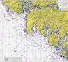
The coordinates for the line posted on the DFO starts at the Pachena Lighthouse - goes straight out 1nm and then heads up the island from there -- I started plotting it using Google Maps.
The area 121 boundary starts at Bonilla Point and the regulation does indeed seem to state that as long as you're fishing within 1nm of shore, the fishery is open and limit is 2.
The area 121 boundary starts at Bonilla Point and the regulation does indeed seem to state that as long as you're fishing within 1nm of shore, the fishery is open and limit is 2.
wildmanyeah
Crew Member
me thinks there will be a lot of creative book work going on this year close to boundary areas.
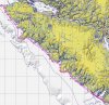
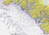
Still working on a map, but until then:
For WCVI this surfline is nothing new, we have been dealing with it for years; the new change being that instead of areas shoreward of the line being closed, they are now open.
So as long as you are within 1nm of shore, you are OK.
The coordinates listed by DFO SHOULD address 20-1, 20-2, and Area 121 but do not. To me, their info in the fisheries notice in contradictory concerning 20-1, 20-2, and Area 121.
bottom feeder
Active Member
Talked to my man in Port Hardy - were fishing !!!!!! top of the island but were fishing !! at least if the boat breaks down we ll be in the charlottes lol
Rob H
Active Member
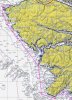
The areas 20-1, 20-2, and 121 are all closed. If you look at the maps these areas start at the shoreline and go way out to the US border. The first areas open are inside waters up near Bamfield (Pachena).Man these changes are confusing. Have a Hali trip booked in June from Renfrew and trying to understand if there will be the opportunity to retain salmon. I got the email notice this morning which states:
Southern BC Recreational Fisheries:
---------------------------------------------------------------------
WCVI Subareas 20-1, 20-2, Area 121, and Areas 123 to 127 seaward of a 1 nm
Boundary Line. The Boundary Line is defined below:
00:01 hours April 19 to 23:59 hours July 14, 2019: Chinook non-retention;
00:01 hours July 15 to 23:59 hours December 31, 2019: 2 Chinook per day
The Boundary Line is approximately 1nm seaward of the surfline and is defined
as follows:
They have listed the coordinates for the boundary line but what they have listed starts at Pacheda Point by Bamfield and then moves up the island.
If I am reading this regulation correctly, SO FAR, it appears that as long as you are inside the 1nm boundary within areas 20-1 and 20-2 Chinook is open. Tried to call and of course, their offices are closed until Tuesday.
...Rob
T
The Jackel
Guest
Everyone have a good Easter weekend there is **** coming down the pipe, fingers crossed
scott craven
Well-Known Member
Just thought I would have another look to make sure they updated the reg's.
Lol !!
Species regulations
Always check for restrictions.
Species Areas Min Size Gear Limits
(d/p/a) Status
Chinook Salmon 19-1 to 19-4 45cm Barbless Hook & Line 2/4/20 Open (See Restrictions)
19-5 to 19-12 62cm Barbless Hook & Line 2/4/15 Open (See Restrictions)
Chum Salmon 19 30cm Barbless Hook & Line 4/8/- Open (See Restrictions)
Coho Salmon (Hatchery & Wild Combined) 19 0/0/0 Non-retention until Jun 01 (See Restrictions)
Pink Salmon 19 30cm Barbless Hook & Line 4/8/- Open (See Restrictions)
Sockeye Salmon 19 30cm Barbless Hook & Line 0/0/0 Non-retention (See Restrictions)
2019-04-19 00:16:10
Restrictions
Always check for protected areas.
Species Areas Measure Type Measure Value
Salmon Coastwide Daily Limit Pieces 4 - The daily limit for all species of Pacific salmon from tidal and fresh waters combined is 4. Individual species limits also apply.
Chinook Salmon Coastwide Reminder Keeping your chinook salmon? You must record (in ink) all retained catch on your Tidal Waters Sport Fishing Licence.
Coastwide Reminder Chinook Salmon Annual Aggregate Counts - The total annual limit for chinook salmon is 10 from all tidal and fresh waters (combined).
Chinook Salmon (Wild) 19-1 to 19-4 Maximum Size (cm) 67 cm
Coho Salmon (Hatchery) Coastwide Reminder Hatchery coho (marked): Coho salmon with a healed scar in place of the adipose fin.
2019-04-19 00:19:32
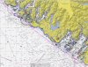
surfline maps - does not include RCA closed areas created using Garmin Homeport (Mac/Windows versions)
List of coordinates used; should be suitable to enter into your GPS:
N48 43.327 W125 05.855
N48 42.456 W125 06.583
N48 46.420 W125 13.997
N48 54.572 W125 33.622
N49 05.100 W125 54.646
N49 10.280 W126 04.790
N49 16.472 W126 15.140
N49 20.008 W126 17.188
N49 23.807 W126 24.483
N49 21.620 W126 28.478
N49 22.113 W126 33.508
N49 23.869 W126 35.333
N49 27.766 W126 35.971
N49 31.494 W126 35.669
N49 34.042 W126 41.611
N49 36.254 W126 50.538
N49 39.892 W126 55.125
N49 44.400 W127 00.289
N49 50.767 W127 10.151
N49 59.142 W127 28.125
N50 06.948 W127 41.617
N50 03.599 W127 47.722
N50 05.868 W127 57.906
N50 19.284 W128 00.130
N50 31.501 W128 14.238
N50 35.683 W128 19.249
N50 39.280 W128 23.459
N50 41.116 W128 24.166
N50 44.137 W128 26.559
N50 47.926 W128 27.363
then to Frederiksen Point.
Attachments
Nice work. I'll have beer and lolipops in my truck all summer. Ukee and/or Tofino x 4 or 5 trips.
pm to claim your prize if you get out that way.
Will-do I hope to hit that area this year for an extended trip as I am retired. I bought the boat I have now (33 ft) to be able to fish the rocks without the crowds, then the surfline closures began. Stamp run is looking good.
You are very welcome. I plan on doing the RCA's for the next rev.thks eric
is this avail as a gpx filesurfline maps - does not include RCA closed areas created using Garmin Homeport (Mac/Windows versions)
List of coordinates used; should be suitable to enter into your GPS:
N48 43.327 W125 05.855
N48 42.456 W125 06.583
N48 46.420 W125 13.997
N48 54.572 W125 33.622
N49 05.100 W125 54.646
N49 10.280 W126 04.790
N49 16.472 W126 15.140
N49 20.008 W126 17.188
N49 23.807 W126 24.483
N49 21.620 W126 28.478
N49 22.113 W126 33.508
N49 23.869 W126 35.333
N49 27.766 W126 35.971
N49 31.494 W126 35.669
N49 34.042 W126 41.611
N49 36.254 W126 50.538
N49 39.892 W126 55.125
N49 44.400 W127 00.289
N49 50.767 W127 10.151
N49 59.142 W127 28.125
N50 06.948 W127 41.617
N50 03.599 W127 47.722
N50 05.868 W127 57.906
N50 19.284 W128 00.130
N50 31.501 W128 14.238
N50 35.683 W128 19.249
N50 39.280 W128 23.459
N50 41.116 W128 24.166
N50 44.137 W128 26.559
N50 47.926 W128 27.363
then to Frederiksen Point.
also lookingfor rca areas in barkley sound in a gpx file as well
the gambler
Active Member
That's info from 2019 just so you know.is this avail as a gpx file
also lookingfor rca areas in barkley sound in a gpx file as well
Charlie415
Crew Member
I have RCA's in gpx format if you want them.
Yes I’m awareThat's info from 2019 just so you know.
Just thought it would be easier to plot the one mile seaward line
yes plsI have RCA's in gpx format if you want them.
ill dm my email
Charlie415
Crew Member
Similar threads
- Replies
- 8
- Views
- 2K
- Replies
- 3
- Views
- 938
- Replies
- 4
- Views
- 901