jcon12
Well-Known Member
The plan is to bundle it into a mobile app once I have all areas, closures etc mapped out. Hoping fairly soon!Great app! When do you think you will have this app ready to download via the Apple app store?
The plan is to bundle it into a mobile app once I have all areas, closures etc mapped out. Hoping fairly soon!Great app! When do you think you will have this app ready to download via the Apple app store?
OSM has some data for coastlines:The plan is to bundle it into a mobile app once I have all areas, closures etc mapped out. Hoping fairly soon!
Considering that the meets and bounds start and end at the nominal high water mark (correct me if I am wrong), It is just a matter of filling that section in with a decent shoreline. I believe DFO uses the CANVEC base data which is federal and free to download and use. There are other data sources available but it is a mute point if you can't import and use a spatial data file such as an ESRI shapefile or DWG/DXF etc.OSM has some data for coastlines:
Not sure how useful it is for your application, but it might be helpful. I wonder if theres a brute force way to achieve coastline coords, by checking the RGB value of the Google maps tile and then querying the lat/long coords. I’m sure that many API calls probably violates the ToS.


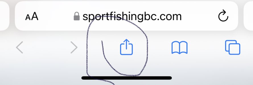
iphone:I can’t find the app in the Apple Store.
What am I doing wrong?
Thank you, learn something new everyday… loliphone:
navigate to website -> share button -> add to home screen
Appreciate ALL the feedbackDay off so I am playing with the app, and yes I have some thoughts. (sorry!)
You are adding improvements a few times a day, thank you, and naming the Fishing Hotspots looks good.
Any chance of a toggle for the ferry routes?
Can the Wind, Wave, and Wave Buoy icons be the first choices in that drop down? Others may not agree, but if there is a consensus, perhaps?
")
Edit***Appreciate ALL the feedback
You want to toggle the ferry routes off I’m assuming? It’s a google thing but I can check if it’s configurable.. or removable.
I am experiencing a minor bug with it (should have resolved this weekend) but have you seen the user settings in the left bar? You can select which layers you want to show on default. But I can definitely look at rearranging as you likely want to constantly toggle things on and off?
I think all they did was book mark the website for easy access on there device .Oh there's an app now? Just iPhone or is there an Android version too? Can't find anything in the store anyway...
Are you using two fingers to scroll?Would it be possible to have a toggle for which areas you want to have data displayed for? I'm not sure if my phone's just getting old, but with such a data heavy map.. mines decently slow to scroll and populate data