Navionics App Price Increase

CBsqrd

Well-Known Member
Heads up, Navionics is increasing the annual subscription price for their app on October 25th from $35 to $50.

However, you can purchase additional years in advance at the current price until then. Open the app, click on “Menu”, select you name / account at the top, then “Subscriptoon”, then “US & Canada” and finally “$34.99” to add another year. Repeat if you want additional years.
 
you have to pay for the app? Like on your phone? I’ve had it for a long time and I don’t think I pay for it
 
you have to pay for the app? Like on your phone? I’ve had it for a long time and I don’t think I pay for it
It just won't update and you lose some features like the dock to dock navigation when you don't renew the subscription yearly
 
Ya, I paid once years ago. Downloaded the charts for the whole coast so it works without cell service. Have been using it ever since without paying.
 
My iPad was still working with auto-navigation when expired but my iPhone wouldn’t. So I upgraded a week ago.

It is the most awesome app so I don’t mind.
 
My iPad was still working with auto-navigation when expired but my iPhone wouldn’t. So I upgraded a week ago.

It is the most awesome app so I don’t mind.
Interesting, neither my phone or tablet would work once it expired. Agreed, great app, worth the money to me.
 
My iPad was still working with auto-navigation when expired but my iPhone wouldn’t. So I upgraded a week ago.

It is the most awesome app so I don’t mind.
Money well spent - I use my phone app and my lap top version of the app a ton. Certainly use the phone app nearly every day I'm out on the water. I can quickly update my phone version with key location weigh points if I spot something on the water that I want to capture and log for future use. Its quicker than dropping a pin on my chart plotter as I can do it from the back of the boat while running the gear. I also really like using the Sonar Chart feature - wow, its amazing detail that has really helped me up my game.
 
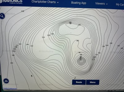
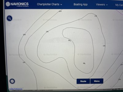
Here’s an example - same location using lower resolution version of regular navionics charts as compared to the Navionics SonarChart version. Night and day difference - top pic is SonarChart, lower is regular Navionics Chart

IMG_4666.jpeg
 

Attachments

  • IMG_4667.jpeg
    IMG_4667.jpeg
    266.8 KB · Views: 24
Money well spent - I use my phone app and my lap top version of the app a ton. Certainly use the phone app nearly every day I'm out on the water. I can quickly update my phone version with key location weigh points if I spot something on the water that I want to capture and log for future use. Its quicker than dropping a pin on my chart plotter as I can do it from the back of the boat while running the gear. I also really like using the Sonar Chart feature - wow, its amazing detail that has really helped me up my game.
Mac laptop? I was told it won’t work on a Windows lap top.
 
Here’s an example - same location using lower resolution version of regular navionics charts as compared to the Navionics SonarChart version. Night and day difference - top pic is SonarChart, lower is regular Navionics Chart

View attachment 99410
Same, I feel blind now without the higher resolution charts. It's no wonder some guys don't do well prawning. I've actually had people tell me that they just wait until the depth reads xxx feet and they drop em'. Seems insane to me
 
I paid $21.95 once about 4 years ago then kept using. Since reading this and checking I have lost use of sonar chart, but still have some basic functions. My prompt to re-new is $79.99.
 
Back
Top