
You are using an out of date browser. It may not display this or other websites correctly.
You should upgrade or use an alternative browser.
You should upgrade or use an alternative browser.
IPad GPS
- Thread starter Bobby
- Start date
I use it on my iPad, my android phone and my wife's iPhone. I like redundancy. It's not just for a backup though. I often have the chart plotter set at one scale(say zoomed in) and the iPad at another (zoomed out). It's nice to be able to see both scales of the map simultaneously. Also, I can move the iPad into the cockpit if I'm fishing near a border or RCA so I can more easily watch it to assure I'm not drifting into places I shouldn't while jigging etc. Also, it's great for route planning from home or for just looking at the map for fishable structure while day dreaming about fishing.
Sir Reel
Well-Known Member
I use it on an iPhone 6 plus and it a great secondary / backup and I have it on my iPad for planning trips. Best $15 investment you can make if you are on the water lots.
When I go to buy charts its $64.99. How did you get for $15?
Fish Assassin
Crew Member
That's how you do itBuy the chart for an iPhone for $15 then sync your iPhone and iPad.
")
I have it on my 6+ and my cellular ipad. Must have pluged into power source if using it all the time.
Sir Reel
Well-Known Member
That doesn't make sense. I wonder if there are features missing on the iPhone version?Buy the chart for an iPhone for $15 then sync your iPhone and iPad.
I looked on my iPhone and it is $16.99 for US and Canada....hmmmmm
Resinrider
Member
The Navionics App for phones or tablets 7" and under is $16. The Navionics App for tablets larger than 7" is called Navionics HD. It is the same App with all the same features, but displays at a higher definition for the bigger screens. It costs around $70
Humpbubble
Active Member
The phone navionics version is lower resolution than the pad one.not a big deal
I bought a third party universal gps receiver that bluetooths to phones,pads,laptops.
Was a hundred bucks,but will never need cell reception or a data package.
I bought a third party universal gps receiver that bluetooths to phones,pads,laptops.
Was a hundred bucks,but will never need cell reception or a data package.
bigbruce
Crew Member
The phone navionics version is lower resolution than the pad one.not a big deal
I bought a third party universal gps receiver that bluetooths to phones,pads,laptops.
Was a hundred bucks,but will never need cell reception or a data package.
Just a note - with an iPad with cellular capability, you don't need either cell reception or a data package. The models with cell capability have GPS built in.
Of course, the gizmo Humpbubble is talking about works too.
Humpbubble
Active Member
Sorry,i cheaped out and have the wifi/bluetooth only pad..phones,pads,compass,charts (laminated)
Redundancy is the key
Redundancy is the key
Resinrider
Member
Clint r, The trial version is exactly the same as the purchased app. On the bottom left corner of the screen ,there are two icons. tap the top one and choose Sonar Charts, then zoom in on the location you will be fishing.
Pippen
Well-Known Member
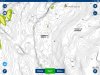
I'm thinking of purchasing this app for my iphone. The free (trial) version seems scant on chart info. Is the full version more detailed? Does it actually show bottom contours and composition? Could I ask someone to post a screen shot of this app in action?
Just an example from full version at mid-zoom. Granted...no "action" as far as GPS/Sonar as I am lying on the couch in my jammies.

Attachments
Similar threads
- Replies
- 19
- Views
- 2K