
Today the traps were in Caddy Bay. Last week OBB hotel. Previous Feb's both have been good. Not this year. There has been at least two different sets of commercial floats pounding it. Can't help but notice a lot of lost, abandoned etc. sport floats as well. Maybe we need to start pulling up some of weed encrusted lines.
- Home
- Forums
- Sport Fishing BC Forums
- Saltwater Fishing Forum
- Archived Saltwater Fishing Reports
- 2022 Saltwater Fishing Reports
You are using an out of date browser. It may not display this or other websites correctly.
You should upgrade or use an alternative browser.
You should upgrade or use an alternative browser.
2022 Victoria and Oak Bay Reports
- Thread starter SFBC
- Start date
- Status
- Not open for further replies.
mbowers
Well-Known Member
Florida has a two week closure on blue crab traps under floats so abandoned traps can be easy identified. Maybe something similar here could help.Today the traps were in Caddy Bay. Last week OBB hotel. Previous Feb's both have been good. Not this year. There has been at least two different sets of commercial floats pounding it. Can't help but notice a lot of lost, abandoned etc. sport floats as well. Maybe we need to start pulling up some of weed encrusted lines.
scott craven
Well-Known Member
Oak bay Crabbing was good for a about 3 weeks in January with lot's of male hard shell dungeness.
In fact there were almost no undersize or female.
That's gone off and they have moved.
Yesterday I had 2 small rock crab in a 3 hour soak.
In fact there were almost no undersize or female.
That's gone off and they have moved.
Yesterday I had 2 small rock crab in a 3 hour soak.
MikeyL
Active Member
Either the crabs got out somehow or maybe the trap got raided...Oak bay Crabbing was good for a about 3 weeks in January with lot's of male hard shell dungeness.
In fact there were almost no undersize or female.
That's gone off and they have moved.
Yesterday I had 2 small rock crab in a 3 hour soak.
Doubt it. Bait untouched and trap exactly where and how I left it. On the positive side. The couple of females I caught were loaded with eggs. It's probably some local environmental thing causing a temporary change in annual routine. Too much fresh water run off this year? Those dang killer whales spent a lot of time in OB last summer.Either the crabs got out somehow or maybe the trap got raided...
") Who knows? Give it a month.
Who knows? Give it a month.ThatswhatSeasaid
Active Member
Sunday Feb. 13th, 5 hours at the mud hole in 290' and nothing but dogs.
The Skeptic
Member
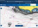
Does anyone know where this actually is?
According to navionics there is a signifigant seamount due south of Brotchie called "fog horn"
I searched all over but never found anything but flat bottom on the sounder. Can anyone advise? It’s just NW of the yellow can bouy on navionics.
We ancheored up and fished anway but only had doggies.

According to navionics there is a signifigant seamount due south of Brotchie called "fog horn"
I searched all over but never found anything but flat bottom on the sounder. Can anyone advise? It’s just NW of the yellow can bouy on navionics.
We ancheored up and fished anway but only had doggies.
Last edited:
Instigator
Member
It's probably best not to anchor in that area for safety reasons as you are likely in the shipping lane. The yellow can is a cautionary buoy. Freighters transition through that area often. Cheers.Does anyone know where this actually is?
According to navionics there is a signifigant seamount due south of Brotchie called "fog horn"
I searched all over but never found anything but flat bottom on the sounder. Can anyone advise? It’s just NW of the yellow can bouy on navionics.
We ancheored up and fished anway but only had doggies.
View attachment 75428
I think it’s an old shipwreck. Not kidding - a ship went down there a long time ago and people used to dive the area for relics.It's probably best not to anchor in that area for safety reasons as you are likely in the shipping lane. The yellow can is a cautionary buoy. Freighters transition through that area often. Cheers.
It’s where capt Brotchie ran his ship aground in 1847. Used to be a popular place to dive for relics!Does anyone know where this actually is?
According to navionics there is a signifigant seamount due south of Brotchie called "fog horn"
I searched all over but never found anything but flat bottom on the sounder. Can anyone advise? It’s just NW of the yellow can bouy on navionics.
We ancheored up and fished anway but only had doggies.
View attachment 75428
tinboatrobb
Well-Known Member
The spot he is looking for is .6 miles south of brotchie ledge. The ship went down on brotchie ledge.
L
Local Hali Hunter
Guest
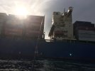
This guy played chicken with us a few years back. Don't go to this spot much anymore but produces every time.It's probably best not to anchor in that area for safety reasons as you are likely in the shipping lane. The yellow can is a cautionary buoy. Freighters transition through that area often. Cheers.
Attachments
Last edited by a moderator:
The Skeptic
Member
The spot is closer to 3 km (1.9 miles) south of the ledge. Itsa slso over a km wide at the widest point. I dont think its a shipwreck.The spot he is looking for is .6 miles south of brotchie ledge. The ship went down on brotchie ledge.
Plus the San Pedro's remains are still at the Ledge itself.
I spoke with the guys at Trotac yesterday and they were unfamiliar with thus lump near the yellow can.
So, has anyone actually seen this seamount?

Last edited:
L
Local Hali Hunter
Guest
Ahh guess its early for you, my picture above is near that spot, hence the Freighter. Yes produces well but pilots don't want you near it. A guy I've known for years who drives the yellow pilot boats says to anchor as close as you can to the pilot buoy if your going fish it. After all, the freighters and even the coho ferry will avoid at all costs getting too close to that buoy. I found it drift jigging and lost a big halibut that later made me go a few sessions to the chiropractor. Risky spot but quite rewarding too.The spot is closer to 3 km (1.9 miles) south of the ledge. Itsa slso over a km wide at the widest point. I dont think its a shipwreck.
Plus the San Pedro's remains are still at the Ledge itself.
I spoke with the guys at Trotac yesterday and they were unfamiliar with thus lump near the yellow can.
So, has anyone actually seen this seamount?
View attachment 75439
The Skeptic
Member
I don't want to take up too much of this thread over this topic, but to clarify are you saying that this hump does actually exist? if so I will submit a ticket to Navionics to reevaluate their chart. Roughly where is it in relation to the yellow can?Ahh guess its early for you, my picture above is near that spot, hence the Freighter. Yes produces well but pilots don't want you near it. A guy I've known for years who drives the yellow pilot boats says to anchor as close as you can to the pilot buoy if your going fish it. After all, the freighters and even the coho ferry will avoid at all costs getting too close to that buoy. I found it drift jigging and lost a big halibut that later made me go a few sessions to the chiropractor. Risky spot but quite rewarding too.
L
Local Hali Hunter
Guest
All I would say is its close, come on man, a Hali Hunter never reveals his spots, otherwise I would be asking Foghorn and that will never happen!!I don't want to take up too much of this thread over this topic, but to clarify are you saying that this hump does actually exist? if so I will submit a ticket to Navionics to reevaluate their chart. Roughly where is it in relation to the yellow can?
Slabbedout
Well-Known Member
All I would say is its close, come on man, a Hali Hunter never reveals his spots, otherwise I would be asking Foghorn and that will never happen!!
The spot exists, I am in doubt anyone that has it marked on their plotter would be willing to share it here.
I have not seen anyone there the last few times I have been out but I will say others have seen and learned from people being anchored there
- Status
- Not open for further replies.
Similar threads
- Replies
- 4
- Views
- 722
- Home
- Forums
- Sport Fishing BC Forums
- Saltwater Fishing Forum
- Archived Saltwater Fishing Reports
- 2022 Saltwater Fishing Reports