El_Kabong
Member
So, the Banana is now closed. If you will all stifle yourselves and quit belly aching, you will see that you have NOTHING to worry about, and there is LOTS of fishing to do and you should get out there and DO IT.
First, the notice that the Banana is closed.
Effective at 23:59 Friday, August 14, 2015 until further notice, fishing for
salmon is not permitted in Subareas 29-6, 29-7, 29-9 and 29-10 and the tidal
waters of the Fraser River.
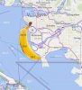
So, where exactly are Subareas 29-6, 29-7, 29-9 and 29-10 you ask?
Schedule II of the Fisheries Act's Pacific Fishery Management Area Regulations, 2007 will tell you where every Sub Area is.
So, let's start with 29-6
29-7
29-9
29-10
So what's all that mean?
Well, look at the area description for 29-3.
29-3 and 29-10 share a common border, in a straight line from the Sandheads light to the Iona Light.
So head out to Sandheads and fish away WEST of the light and you will be fine.
What about the T10 Buoy?
The Notice to Mariners says that it is at 49°10.594'N 123°17.467'W.
The T10 Buoy is just ever so slightly WEST of the border between 29-3 and 29-10. So if you keep WEST of the T10, you can fish there for salmon too.
There is nothing to worry about here folks. Just stay WEST of the line between 29-3 and 29-10, The Banana Line. Keep an eye on your GPS and keep those lines in the water!
First, the notice that the Banana is closed.
Effective at 23:59 Friday, August 14, 2015 until further notice, fishing for
salmon is not permitted in Subareas 29-6, 29-7, 29-9 and 29-10 and the tidal
waters of the Fraser River.
So, where exactly are Subareas 29-6, 29-7, 29-9 and 29-10 you ask?
Schedule II of the Fisheries Act's Pacific Fishery Management Area Regulations, 2007 will tell you where every Sub Area is.
So, let's start with 29-6
Those waters of the Strait of Georgia inside a line that begins at 49°05.262′N 123°18.615′W [Roberts Bank radar beacon], then to 49°02.290′N 123°15.378′W [Canoe Passage Light Buoy LL308], then through 49°00.130′N 123°07.718′W [Tsawwassen Ferry Breakwater Light] to the intersection with the international boundary between Canada and the United States then following the international boundary westerly to the point of intersection with a line drawn 176° true from Roberts Bank radar beacon then to the beginning point.
29-7
Those waters of the Strait of Georgia inside a line that begins at 49°02.290′N 123°15.378′W [Canoe Passage Light Buoy LL308], then to 49°04.094′N 123°09.165′W [near Brunswick Cannery], then southerly following the shoreline to the intersection with the international boundary between Canada and the United States then following the international boundary to the intersection with a line drawn, from the 49°02.290′N 123°15.378′W [Canoe Passage Light Buoy LL308], straight through 49°00.130′N 123°07.718′W [Tsawwassen Ferry Breakwater Light] to the international boundary then following that line to the beginning point.
29-9
Those waters of the Strait of Georgia inside a line that begins at 49°06.358′N 123°18.188′W [Sand Heads Light], then following Steveston Jetty to 49°07.468′N 123°11.830′W [Garry Point], then easterly following the shoreline to 49°06.932′N 123°09.355′W [Lulu Island], then to 49°06.850′N 123°09.434′W [Steveston Island], hen following the northerly shoreline of Steveston Island to 49°06.989′N 123°10.102′W [Steveston Island] then true south to 49°06.386′N 123°10.102′W [Reifel Island],
then following the westerly shoreline of Reifel Island and Westham Island to 49°04.349′N 123°09.165′W [Westham Island] then true south to 49°04.094′N 123°09.165′W [near Brunswick Cannery],
then to 49°02.290′N 123°15.378′W [Canoe Passage Light Buoy LL308] then to 49°05.262′N 123°18.615′W [Roberts Bank radar beacon] then to the beginning point.
29-10
Those waters of the Strait of Georgia inside a line that begins at 49°15.440′N 123°16.778′W [North Arm Jetty Light] then following the southerly shoreline of Iona Island and the westerly shoreline of Sea Island to 49°11.238′N 123°12.571′W [Sea Island] then to 49°10.459′N 123°11.998′W [Lulu Island]
then southerly following the shoreline to 49°07.468′N 123°11.830′W[Garry Point], then following Steveston Jetty to 49°06.358′N 123°18.188′W [Sand Heads Light] then to the beginning point.
So what's all that mean?
Well, look at the area description for 29-3.
Those waters of the Strait of Georgia inside a line that begins at 49°23.021′N 123°32.166′W [Gower Point], then to 49°21.500′N 123°29.157′W [Popham Island], then to 49°20.907′N 123°27.903′W [Worlcombe Island], then to 49°20.397′N, 123°25.979′W [Cape Roger Curtis] then, following the southerly shoreline of Bowen Island to 49°20.135′N 123°21.643′W [Point Cowan], then to 49°19.823′N 123°15.880′W [Point Atkinson Light], then to 49°15.936′N 123°15.860′W [Point Grey], then to 49°15.440′N 123°16.778′W, [North Arm Jetty Light],then to 49°06.358′N 123°18.188′W [Sand Heads Light],
then to 49°08.997′N 123°38.497′W [Thrasher Rock Light], then to the beginning point.
29-3 and 29-10 share a common border, in a straight line from the Sandheads light to the Iona Light.
So head out to Sandheads and fish away WEST of the light and you will be fine.
What about the T10 Buoy?
The Notice to Mariners says that it is at 49°10.594'N 123°17.467'W.
The T10 Buoy is just ever so slightly WEST of the border between 29-3 and 29-10. So if you keep WEST of the T10, you can fish there for salmon too.
There is nothing to worry about here folks. Just stay WEST of the line between 29-3 and 29-10, The Banana Line. Keep an eye on your GPS and keep those lines in the water!