Sharphooks
Well-Known Member
Not sure if any of you guys have tried out the new Doppler technology in recreational marine radar. I thought it would be a good addition to the boat for a safety factor —-boat positional awareness in pea-soup fog and for running at night—-and figured I’d post about some of its attributes
I just installed the Furuno DRS4D-NXT on my boat and had a chance to fire it up and put it through its paces yesterday. Pretty amazing target return when you switch it to “Target Analyzer”—-this setting is essentially the Doppler setting. The radar has built-in ARPA so if you’re near a shipping lane and get an ARPA target, you get a screen icon that shows the vessel, the direction it’s heading, the speed its running at and what the “CPA” will be (closest point of approach = potential collision)
I unintentionally disabled the AIS on my VHF radio when I switched chartplotters on my boat (the new chart plotter is strictly NMEA2K and the radio outputs in NMEA0183 so I lost my AIS returns on the chartplotter screen
But having ARPA and Doppler capabilities more then makes up for losing AIS
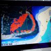
Here’s the first screen-shot I saw when I fired up the radar in the lagoon where I moor my boat: the red target just to starboard of my heading sensor line is a mud flat just starting to show in my lagoon as the tide recedes...

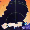
The second shot shows a duck (the blue target) that was swimming 10 feet off my port bow: I was impressed how the beam could pick up something so close to the boat

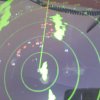
This next shot is in crappy focus—-there was some wave action and lots of boats around so I just grabbed a quick pic—-I was in a fleet of sailboats—-but they all had their spinnakers up and fully inflated which meant the wind was directly behind them and they were coming towards me——thus, the red color of all those targets which is how the Doppler marks approaching targets. The lone green target was a salmon troller going away from me—-thus, the color green
You can also see what the ARPA lollipops look like, showing course and speed

So the back-story of what made me bust this Doppler move was a little adventure I had crossing QCS last August—-impenetrable pea-soup fog....what else is new? I had my eyes glued to the radar screen (conventional radar with a magnetron) . I was going maybe 10 knots, minding my own business when a large cruiser showed up out of nowhere and steams right next to me on a similar course and similar speed—-a big red target showing on the screen off my port beam.
I have a full chart on my other chartplotter screen— I don’t like overlay—-too much information going on. I’m threading through a fairly narrow spot and I see it clearly on the chart—-rock on one side, reef on the other. It’s an “obvious” route if you’re crossing from Caution to Hardy and the cruiser next to me had the same idea I did. Then suddenly the two red targets ahead of me (rocks? Boats?) had become three red targets. I knew one, maaaybe two, of the targets were rocks (depending on the tide and how much they were exposed...) The third target had come out of nowhere—-but was it coming or going? Had it been ahead of me all this time but my gain hadn’t been cranked high enough to see it??
So all this sounds like small beer sitting in a brightly lit room at a table but when you’re solo in the middle of white-out conditions in QFC and you’ve lost all spatial and positional awarenes, it pretty quickly becomes sweaty palm stuff.
But you’ve made your move, you stick to the route because now there are known rocks straight ahead and you can’t afford to recalibrate at this stage....
So my first thought was after I’d threaded the rock/boat target needle was....wow, wouldn’t it be nice to have Doppler technology right about now?
So now I’m loaded for bear for my next trip to North Coast...but funny thing....while fiddling with the buttons of my new toy, I almost ran into a 300 foot long ferry...
So I’d better shut up about all this fancy new technology I just installed on my boat and going forward, promised myself I’ll focus on paying attention with my eyes and ears and use the Doppler as Plan B....
I just installed the Furuno DRS4D-NXT on my boat and had a chance to fire it up and put it through its paces yesterday. Pretty amazing target return when you switch it to “Target Analyzer”—-this setting is essentially the Doppler setting. The radar has built-in ARPA so if you’re near a shipping lane and get an ARPA target, you get a screen icon that shows the vessel, the direction it’s heading, the speed its running at and what the “CPA” will be (closest point of approach = potential collision)
I unintentionally disabled the AIS on my VHF radio when I switched chartplotters on my boat (the new chart plotter is strictly NMEA2K and the radio outputs in NMEA0183 so I lost my AIS returns on the chartplotter screen
But having ARPA and Doppler capabilities more then makes up for losing AIS
Here’s the first screen-shot I saw when I fired up the radar in the lagoon where I moor my boat: the red target just to starboard of my heading sensor line is a mud flat just starting to show in my lagoon as the tide recedes...

The second shot shows a duck (the blue target) that was swimming 10 feet off my port bow: I was impressed how the beam could pick up something so close to the boat

This next shot is in crappy focus—-there was some wave action and lots of boats around so I just grabbed a quick pic—-I was in a fleet of sailboats—-but they all had their spinnakers up and fully inflated which meant the wind was directly behind them and they were coming towards me——thus, the red color of all those targets which is how the Doppler marks approaching targets. The lone green target was a salmon troller going away from me—-thus, the color green
You can also see what the ARPA lollipops look like, showing course and speed

So the back-story of what made me bust this Doppler move was a little adventure I had crossing QCS last August—-impenetrable pea-soup fog....what else is new? I had my eyes glued to the radar screen (conventional radar with a magnetron) . I was going maybe 10 knots, minding my own business when a large cruiser showed up out of nowhere and steams right next to me on a similar course and similar speed—-a big red target showing on the screen off my port beam.
I have a full chart on my other chartplotter screen— I don’t like overlay—-too much information going on. I’m threading through a fairly narrow spot and I see it clearly on the chart—-rock on one side, reef on the other. It’s an “obvious” route if you’re crossing from Caution to Hardy and the cruiser next to me had the same idea I did. Then suddenly the two red targets ahead of me (rocks? Boats?) had become three red targets. I knew one, maaaybe two, of the targets were rocks (depending on the tide and how much they were exposed...) The third target had come out of nowhere—-but was it coming or going? Had it been ahead of me all this time but my gain hadn’t been cranked high enough to see it??
So all this sounds like small beer sitting in a brightly lit room at a table but when you’re solo in the middle of white-out conditions in QFC and you’ve lost all spatial and positional awarenes, it pretty quickly becomes sweaty palm stuff.
But you’ve made your move, you stick to the route because now there are known rocks straight ahead and you can’t afford to recalibrate at this stage....
So my first thought was after I’d threaded the rock/boat target needle was....wow, wouldn’t it be nice to have Doppler technology right about now?
So now I’m loaded for bear for my next trip to North Coast...but funny thing....while fiddling with the buttons of my new toy, I almost ran into a 300 foot long ferry...
So I’d better shut up about all this fancy new technology I just installed on my boat and going forward, promised myself I’ll focus on paying attention with my eyes and ears and use the Doppler as Plan B....
Last edited:

