Chasin' Dreams
Well-Known Member
Fresh off the presses, cut and paste of the new notice:
FN0322-RECREATIONAL - Salmon - Chinook - Areas 11 to 28, 111, 121 to 127 and Subareas 29-1 to 29-5 and 29-8 - Chinook Management Measures - Effective April 1, 2020
Category(s):
RECREATIONAL - Salmon
Fishery Notice - Fisheries and Oceans Canada
Subject: FN0322-RECREATIONAL - Salmon - Chinook - Areas 11 to 28, 111, 121 to 127 and Subareas 29-1 to 29-5 and 29-8 - Chinook Management Measures - Effective April 1, 2020
To address conservation concerns for at-risk Fraser River Chinook stocks, DFO
is continuing precautionary reductions in commercial, recreational and First
Nation’s fisheries to support conservation of these stocks. This Fishery Notice
provides the interim recreational fishery management measures to provide
protection to at-risk Fraser River Chinook stocks in Areas 11 to 28, 121 to 127
and Subareas 29-1 to 29-5 and 29-8. The plan is to start the 2020 fishing
season (beginning April 1, 2020) with the measures that were in place at the
beginning of last season (April 2019) until further notice. As these are
interim measures, a further announcement on possible revised management actions
is anticipated in June 2020. The Sport Fishing Advisory Board (SFAB) is being
consulting on potential changes to the 2020 fishing plan.
The management measures for Fraser Chinook are outlined below.
---------------------------------------------------------------------------
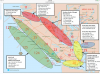
Southern BC Recreational Fisheries:
---------------------------------------------------------------------------
West Coast Vancouver Island (WCVI) Subareas 20-1 and 20-2, Area 121, as well as
Areas 123 to 127 seaward of a Boundary Line located approximately one (1)
nautical mile from the surfline:
00:01 hours April 1 until further notice, Chinook non-retention.
For the full definition of the Boundary Line in Areas 123 to 127, please see
the bottom of this fishery notice.
Chinook daily limits remain at two (2) per day shoreward of this boundary line.
Queen Charlotte and Johnstone Straits (Subareas 12-1 to 12-13, 12-15 to 12-48):
00:01 hours April 1 until further notice, Chinook non-retention.
Strait of Georgia - North - Areas 13 to 17, Area 28, and Subareas 29-1 and 29-2:
00:01 hours April 1 until further notice, Chinook non-retention;
Strait of Georgia - South and Juan de Fuca - Area 18, Subareas 19-3 to 19-12,
20-3 to 20-7, and Subareas 29-3 to 29-5 and 29-8:
00:01 hours April 1 to 23:59 hours July 31, 2020, Chinook non-retention;
For clarity, Chinook retention is permitted in Areas 11, 21 to 27, 111, Subarea
12-14, and those portions of Areas 123 to 127 shoreward of a Boundary Line
located approximately one (1) nautical mile seaward of the surfline.
Variation Order: 2020-RFQ-0145, 2020-RFQ-147.
---------------------------------------------------------------------------
Definition: Boundary Line for Areas 123 to 127
---------------------------------------------------------------------------
The Boundary Line is approximately one (1) nautical mile seaward of the
surfline and is defined as follows:
A line that begins at Pacheena Point lighthouse at 48 degrees 43.327' N 125
degrees 05.855' W
then to 48 degrees 42.456' N 125 degrees 06.583' W seaward of Pachena Point,
then to 48 degrees 46.420' N 125 degrees 13.997' W seaward of Cape Beale,
then to 48 degrees 54.572' N 125 degrees 33.622' W seaward of Amphitrite Point,
then to 49 degrees 05.100' N 125 degrees 54.646' W seaward of Cox Point,
then to 49 degrees 10.280' N 126 degrees 04.790' W seaward of Blunden Island,
then to 49 degrees 16.472' N 126 degrees 15.140' W seaward of Rafael Point,
then to 49 degrees 20.008' N 126 degrees 17.188' W seaward of Sydney Inlet,
then to 49 degrees 23.807' N 126 degrees 24.483' W seaward of Hesquiat Point,
then to 49 degrees 21.620' N 126 degrees 28.478' W seaward of Matlahaw Point,
then to 49 degrees 22.113' N 126 degrees 33.508' W seaward of Estevan Point,
then to 49 degrees 23.869' N 126 degrees 35.333' W seaward of Homais Cove,
then to 49 degrees 27.766' N 126 degrees 35.971' W seaward of Split Cape,
then to 49 degrees 31.494' N 126 degrees 35.669' W seaward of Escalante Point,
then to 49 degrees 34.042' N 126 degrees 41.611' W seaward of Maquinna Point,
then to 49 degrees 36.254' N 126 degrees 50.538' W seaward of Bajo Point,
then to 49 degrees 39.892' N 126 degrees 55.125' W seaward of Skuna Bay,
then to 49 degrees 44.400' N 127 degrees 00.289' W seaward of Ferrer Point,
then to 49 degrees 50.767' N 127 degrees 10.151' W seaward of Tatchu Point,
then to 49 degrees 59.142' N 127 degrees 28.125' W seaward of Lookout Island,
then to 50 degrees 06.948' N 127 degrees 41.617' W seaward of Jackobson Point,
then to 50 degrees 03.599' N 127 degrees 47.722' W seaward of Clerke Point,
then to 50 degrees 05.868' N 127 degrees 57.906' W seaward of Solander Island,
then to 50 degrees 19.284' N 128 degrees 00.130' W seaward of Lawn Point,
then to 50 degrees 31.501' N 128 degrees 14.238' W seaward of Topknot Point,
then to 50 degrees 35.683' N 128 degrees 19.249' W seaward of Cape Palmerston,
then to 50 degrees 39.280' N 128 degrees 23.459' W seaward of Winifred Island,
then to 50 degrees 41.116' N 128 degrees 24.166' W seaward of Cape Russell,
then to 50 degrees 44.137' N 128 degrees 26.559' W seaward of Strange Rock,
then to 50 degrees 47.926' N 128 degrees 27.363' W seaward of Cape Scott,
then to Frederiksen Point.
FN0322-RECREATIONAL - Salmon - Chinook - Areas 11 to 28, 111, 121 to 127 and Subareas 29-1 to 29-5 and 29-8 - Chinook Management Measures - Effective April 1, 2020
Category(s):
RECREATIONAL - Salmon
Fishery Notice - Fisheries and Oceans Canada
Subject: FN0322-RECREATIONAL - Salmon - Chinook - Areas 11 to 28, 111, 121 to 127 and Subareas 29-1 to 29-5 and 29-8 - Chinook Management Measures - Effective April 1, 2020
To address conservation concerns for at-risk Fraser River Chinook stocks, DFO
is continuing precautionary reductions in commercial, recreational and First
Nation’s fisheries to support conservation of these stocks. This Fishery Notice
provides the interim recreational fishery management measures to provide
protection to at-risk Fraser River Chinook stocks in Areas 11 to 28, 121 to 127
and Subareas 29-1 to 29-5 and 29-8. The plan is to start the 2020 fishing
season (beginning April 1, 2020) with the measures that were in place at the
beginning of last season (April 2019) until further notice. As these are
interim measures, a further announcement on possible revised management actions
is anticipated in June 2020. The Sport Fishing Advisory Board (SFAB) is being
consulting on potential changes to the 2020 fishing plan.
The management measures for Fraser Chinook are outlined below.
---------------------------------------------------------------------------
Southern BC Recreational Fisheries:
---------------------------------------------------------------------------
West Coast Vancouver Island (WCVI) Subareas 20-1 and 20-2, Area 121, as well as
Areas 123 to 127 seaward of a Boundary Line located approximately one (1)
nautical mile from the surfline:
00:01 hours April 1 until further notice, Chinook non-retention.
For the full definition of the Boundary Line in Areas 123 to 127, please see
the bottom of this fishery notice.
Chinook daily limits remain at two (2) per day shoreward of this boundary line.
Queen Charlotte and Johnstone Straits (Subareas 12-1 to 12-13, 12-15 to 12-48):
00:01 hours April 1 until further notice, Chinook non-retention.
Strait of Georgia - North - Areas 13 to 17, Area 28, and Subareas 29-1 and 29-2:
00:01 hours April 1 until further notice, Chinook non-retention;
Strait of Georgia - South and Juan de Fuca - Area 18, Subareas 19-3 to 19-12,
20-3 to 20-7, and Subareas 29-3 to 29-5 and 29-8:
00:01 hours April 1 to 23:59 hours July 31, 2020, Chinook non-retention;
For clarity, Chinook retention is permitted in Areas 11, 21 to 27, 111, Subarea
12-14, and those portions of Areas 123 to 127 shoreward of a Boundary Line
located approximately one (1) nautical mile seaward of the surfline.
Variation Order: 2020-RFQ-0145, 2020-RFQ-147.
---------------------------------------------------------------------------
Definition: Boundary Line for Areas 123 to 127
---------------------------------------------------------------------------
The Boundary Line is approximately one (1) nautical mile seaward of the
surfline and is defined as follows:
A line that begins at Pacheena Point lighthouse at 48 degrees 43.327' N 125
degrees 05.855' W
then to 48 degrees 42.456' N 125 degrees 06.583' W seaward of Pachena Point,
then to 48 degrees 46.420' N 125 degrees 13.997' W seaward of Cape Beale,
then to 48 degrees 54.572' N 125 degrees 33.622' W seaward of Amphitrite Point,
then to 49 degrees 05.100' N 125 degrees 54.646' W seaward of Cox Point,
then to 49 degrees 10.280' N 126 degrees 04.790' W seaward of Blunden Island,
then to 49 degrees 16.472' N 126 degrees 15.140' W seaward of Rafael Point,
then to 49 degrees 20.008' N 126 degrees 17.188' W seaward of Sydney Inlet,
then to 49 degrees 23.807' N 126 degrees 24.483' W seaward of Hesquiat Point,
then to 49 degrees 21.620' N 126 degrees 28.478' W seaward of Matlahaw Point,
then to 49 degrees 22.113' N 126 degrees 33.508' W seaward of Estevan Point,
then to 49 degrees 23.869' N 126 degrees 35.333' W seaward of Homais Cove,
then to 49 degrees 27.766' N 126 degrees 35.971' W seaward of Split Cape,
then to 49 degrees 31.494' N 126 degrees 35.669' W seaward of Escalante Point,
then to 49 degrees 34.042' N 126 degrees 41.611' W seaward of Maquinna Point,
then to 49 degrees 36.254' N 126 degrees 50.538' W seaward of Bajo Point,
then to 49 degrees 39.892' N 126 degrees 55.125' W seaward of Skuna Bay,
then to 49 degrees 44.400' N 127 degrees 00.289' W seaward of Ferrer Point,
then to 49 degrees 50.767' N 127 degrees 10.151' W seaward of Tatchu Point,
then to 49 degrees 59.142' N 127 degrees 28.125' W seaward of Lookout Island,
then to 50 degrees 06.948' N 127 degrees 41.617' W seaward of Jackobson Point,
then to 50 degrees 03.599' N 127 degrees 47.722' W seaward of Clerke Point,
then to 50 degrees 05.868' N 127 degrees 57.906' W seaward of Solander Island,
then to 50 degrees 19.284' N 128 degrees 00.130' W seaward of Lawn Point,
then to 50 degrees 31.501' N 128 degrees 14.238' W seaward of Topknot Point,
then to 50 degrees 35.683' N 128 degrees 19.249' W seaward of Cape Palmerston,
then to 50 degrees 39.280' N 128 degrees 23.459' W seaward of Winifred Island,
then to 50 degrees 41.116' N 128 degrees 24.166' W seaward of Cape Russell,
then to 50 degrees 44.137' N 128 degrees 26.559' W seaward of Strange Rock,
then to 50 degrees 47.926' N 128 degrees 27.363' W seaward of Cape Scott,
then to Frederiksen Point.
")