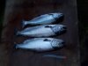
I put in a long solo shift around the otter/trailer park area yesterday from sunrise to 230. There was a bite from sunrise to about 830, then it slowed some for a few hours (except for those few boats fishing exclusively in the closed area (while being filmed by a man on the point with a tripod), then the bite came on again with the flood around noon. I lost a mid-teen that charged the boat, then another in the morning, then got two chinook and a hatch coho about 7lbs on the outside of the otter point fleet between 1230 and 230. Small chovie in bloody nose, electric chair hootchie, and the reliable AP sandlance were all getting hits. Shakers were frequent, so check your gear regularly for unannounced hitchhikers
THEY were not in the closed area WHY do you guys say this **** .... most are playing by the rules the boundry is the flag pole im so tired of people whining about this PHONE DFO and say get rid of the boundry and MOST fish were not caught there .... need to open your eyes did you see me anywhere near there??? IMO
Is there some insider thing going on here that the rest of us are missing? Lol

")


