Low snowpack could be ‘disastrous’ for salmon, scientist says

agentaqua

Well-Known Member
http://bc.ctvnews.ca/low-snowpack-could-be-disastrous-for-salmon-scientist-says-1.2259354
fishing chilliwack river
An angler hooks a fish on the Chilliwack River on Sunday, March 1, 2015. (CTV)
CTV Vancouver
Published Sunday, March 1, 2015 4:17PM PST
Last Updated Sunday, March 1, 2015 4:23PM PST

An unusually mild winter in B.C. could spell trouble for salmon populations in streams and rivers this summer, according to local scientists.

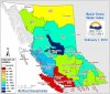
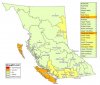
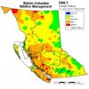
The concerns come as snowpack levels on some B.C. mountains are a mere fraction of what they should be due to warm temperatures.

“Snowpacks on the island are around 30 per cent of average conditions and similar so in the lower Fraser and in the South Coast,” said Tobi Gardner, a hydrologist with the BC River Forecast Centre. “It’s been a warm winter, so the warm temperatures just haven’t allowed a snowpack to accumulate. And then the second factor is that when big precipitation events have hit the coast, the weather’s been warm, so that precipitation has been rain.”

Bare ski runs on Cypress Mountain are seen from CTV's Chopper 9 helicopter. Feb. 24, 2015.
One local scientist believes the reduced snowpack could put salmon populations at risk come summertime – leading to potentially disastrous results.

“It can have an impact during summer when water levels are low…and in the fall when migrating salmon return home to spawn,” said Dr. Ken Ashley of the BCIT Rivers Institute. “If its low flows and high temperatures, this could be sort of disastrous for salmonids,” he said.

For one, low water levels mean salmon are much easier prey for predators like raccoons and birds.

Also of concern is that as water temperatures warm up, diseases are able propagate more quickly.

“If a disease outbreak, if one fish was diseased, they tend to get the disease more quickly in warm water than cold water,” Ashley said. “Everything grows faster in warmer temperatures. Bacteria grow faster, algae grow faster, everything grows faster.”

The concerns come as local ski mountains grapple with bare slopes caused by the lack of snow.

Scientists say the freezing level has been unusually high this year, causing precipitation to fall on the mountains as rain.

One UBC Okanagan professor predicts that scarce snow could become the norm by 2085 if greenhouse gases continue to increase.
With a report from CTV Vancouver's Michele Brunoro
 
Last edited by a moderator:
Would not be too surprised if they decide not to open the Fraser for the annual sockeye gong show.
 
I was in the upper Chilliwack River watershed this morning and water levels are very low for this time of year. As mentioned, the mountains are pretty much devoid of snow, up to about the 5,000 ft level. Unless more snow comes in March and April ( entirely possible, and here's hoping ...), September water levels in this system may reach record lows, with subsequent impacts to rearing salmonids. Thank God for the controlled flow off channel habitat that has been created over the years on this river.
 
Water woes: Low snowpack no reason to worry about summer reservoir levels, say experts

Water woes: Low snowpack no reason to worry about summer reservoir levels, say experts
Warm tropical rains and above-average temperatures left much of B.C.’s South Coast without a winter this year, but experts are wagering a lack of snowpack won’t mean water shortages this spring and summer.

“We’re actually in really good shape for this time of year and we don’t expect any concerns at all for being full for the start of the summer season,” said Marilyn Towill, division manager of water services transmission operations at Metro Vancouver Regional District.

Metro Vancouver manages the Coquitlam, Seymour and Capilano watersheds, which span about 60,000 hectares and provide water to more than 2.3 million Metro Vancouver residents, roughly half of B.C.’s population.

Towill said it’s too early to make predictions for the summer water supply, but reservoir levels are “typical for this time of year” and a few big rainfalls should bring them up to 100 per cent by May.

“The rain events are particularly important,” Towill said.

“The snow acts more as a slow release, kind of that buffer that sits there and gives us that slow melt that replenishes our storage reservoir in the late spring, early summer”

A monthly bulletin from B.C.’s River Forecast Centre (RFC) highlighted how higher-than-normal temperatures in January meant rainfall, not snow, was the dominant form of precipitation for mid-elevation terrain.

RFC data from Feb. 1 showed “extremely low” snowpacks throughout Vancouver Island and southwestern B.C., including the Lower Fraser and South Coast snow basins.

That doesn’t mean the snowpack’s a lost cause, according to RFC hydrologist Tobi Gardner.

“There is still a fair bit of time between now and the end of the peak accumulation period, so let’s hold tight,” Gardner said.

“A lot can change, snowpack-wise, in a short period of time. Last year, in March, that’s when the biggest changes occurred. The snowpack bumped up from roughly 10 to 20 per cent on the South Coast and Lower Fraser between March 1 and April 1.”

RFC data shows most of the province was experiencing “near-normal” and “slightly below normal” snowpacks by Feb. 1 this year.

Years with below-average snowfall could become more common as the climate warms, said Markus Schnorbus, lead of hydrologic impacts for the Pacific Climate Impacts Consortium.

“I can’t take any one year of an anomalously low snowpack and confidently contribute it to climate change — it could be related to a number of factors, but ... our research suggests as the climate gets warmer, this would be something that would potentially occur more often,” Schnorbus said.

neagland@theprovince.com

twitter.com/nickeagland

© Copyright (c) The ProvinceOn the positive side.
 
Water woes: Low snowpack no reason to worry about summer reservoir levels, say experts

Water woes: Low snowpack no reason to worry about summer reservoir levels, say experts
Warm tropical rains and above-average temperatures left much of B.C.’s South Coast without a winter this year, but experts are wagering a lack of snowpack won’t mean water shortages this spring and summer.

“We’re actually in really good shape for this time of year and we don’t expect any concerns at all for being full for the start of the summer season,” said Marilyn Towill, division manager of water services transmission operations at Metro Vancouver Regional District.

.
All well and good for drinking water supplies and for those systems, but the unregulated systems will be in dire straits this summer (predicted to have warmer than normal temperatures by Environment Canada) if we do not have monsoons in June. :(
 
Not good for the latest reports.
http://bcrfc.env.gov.bc.ca/bulletins/watersupply/current.htm


WeatherTemperatures across British Columbia continued to be well above normal through the monthof February. Temperatures were generally 3-5°C above normal, with the largesttemperature anomalies occurring in southwest British Columbia. February sea surfacetemperature anomalies in the Pacific Ocean off the shores of British Columbia havecontinued to be several degrees above normal.February precipitation trends have been varied across the province. Vancouver Island,South Coast, and the Kootenay’s experienced below normal precipitation. Above normalprecipitation occurred in the Okanagan, Central Interior, Northwest and Northeast BC. Withincreased temperatures, rainfall was the dominant form of precipitation through midelevationterrain.Snow PackSnow pack accumulation trends from early in the season have persisted throughoutFebruary. Modest declines in snow basin indices were observed in most basins between theFebruary and March surveys. With the exception of the Upper Fraser West, all regions of theprovince have near normal or below normal March 1st snow basin indices (Figure 1). Snowbasin indices range from a low of 15 % on the South Coast to a high of 142% of in UpperFraser West (Table 1 and Figure 1).


Check out page 13 in this PDF to see how it compares to last year. We have a problem for south coast and VI. Page 11 for lower Fraser is bad too.
http://bcrfc.env.gov.bc.ca/bulletins/2015_Mar1.pdf


SnowIndexMap.jpg
 
Last edited by a moderator:
No improvement for April for South Coast, VI and Lower Fraser
Expect problems and plan ahead.
SnowIndexMap.jpg
 
GLG, I agree 100% and on the Chilliwack River one way to plan ahead is to ensure as much water as needed is sent to the most critical off channel areas. On this system DFO, the Province, and the Fraser Valley Watersheds Coalition through funding from the PSF, have built several controlled flow spawning and rearing areas ... yeah, the habitat is there but limited money is available to maintain these crucial sites .. and without water they are useless.

I and other volunteers will be monitoring spawning steelhead in the upper reaches of the Chilliwack for the 5th consecutive year this spring; if interested in our findings check out Rodney's site.
 
It's not looking good folks this year for our salmon.
Need the community to go "salmon friendly" this year on our lawns.
I'm sure the call will go out come June if we don't get rain.

http://www.comoxvalleyecho.com/news/local-news/valley-enters-uncharted-territory-1.1935502


[h=3]Comox Valley enters 'uncharted territory'[/h][h=4]Water warning over low snowpack and unusual weather[/h]BC Hydro is warning the Comox Valley is now entering "uncharted territory" that could impact public water supplies this summer.
Not once in the past 50 years have records shown anything like the conditions now being noted around Comox Lake, from which flows the water supply for all of Courtenay, Comox and some surrounding rural areas.
Around 40,000 residents and businesses rely on supplies piped and treated by Comox Valley Regional District, but sourced from BC Hydro, which manages the lake.
BC Hydro spokesperson Stephen Watson told the Echo the past several months had been a tale of weather extremes. There had been record-setting storms, but also prolonged dry periods and most notably a record low snowpack on the mountains.
At one snow measuring station at an elevation of 1,600m - as high as the peak of Mount Washington - no snow at all had accumulated since mid-January.
That set the first alarm bells ringing, as the slow release of water from the melting snowpack is usually vital in keeping Comox Lake topped up for several months a year, especially in prolonged dry periods.
BC Hydro itself is by far the biggest user of water from the lake, drawing on it to turn the turbines at its power generating station further down the Puntledge.
But in April, much earlier than usual, it began conserving water and has since been operating the power station at about a fifth of its full capacity. The consequential reduction in electricity supplies has been made up for customers with power drawn through cables under the Georgia Strait from the Lower Mainland.
"The April water inflows into the reservoir were low, only 65 per cent of average," Watson explained. "For May, given the dry start to the month and the very low snowpack, water inflows are now setting new (low) records.
"Currently about 11-13 cubic metres a second is entering the reservoir, which is the lowest we've seen for this time of year in about 50 years."
Late last week the reservoir depth was 134.9 m and slowly dropping, but that is only half a metre below what is considered full.
So, people might ask, what's the problem? The numbers make it look as though there is almost limitless water available.
While it's true there is a lot of water, most of it cannot be tapped. Huge volumes can only flow from the lake by gravity - at least until a multi-million dollar deep-water intake pumping system can be installed. The lowest surface level at which bulk water can be extracted is around 131 metres.
And if dry weather continues the surface level could sink pretty rapidly.
"The key indicator is the residual water supply forecast, from May to September, is showing just 44 per cent of normal," Watson noted. "This is uncharted territory."
BC Hydro is responsible for managing water from the lake for all approved users, including flows down the Puntledge River to ensure healthy fish habitat and even occasional water releases for recreation.
Such releases include those for the annual multi-day kayak paddle festival at the end of May, when normally there is so much water around it is being deliberately spilled over the dam at the lake.
"With due discretion on what could be extremely low water conditions this summer, all parties came to the conclusion that the multi-day Puntledge Paddle Festival and the multi-day water release for chinook smolts will not happen this year," said Watson.
"This is the first time this has occurred since a water use plan was agreed between many parties and implemented in 2004."
He added: "Unfortunately, with low precipitation, the record low snowpack, and the dry forecast ahead, the water conditions are quickly moving to extreme. We are seeing water inflows into the reservoir similar to July, not early May."
Watson said BC Hydro would likely maintain its current low discharge of about 15-16 cubic metres a second from Comox dam, and run the generating station at about 20 per cent of capacity, for the weeks and months ahead.
Such a flow would still keep fish habitat covered, even if it would not provide the powerful bursts of water to help sweep smolts out to sea, aimed at giving them a better chance of surviving predator seals.
"Operational adjustments will be made as needed," he said. "BC Hydro will continue working with Fisheries and Oceans Canada in the coming weeks to discuss upstream inflows, Puntledge River flow conditions, and any minor adjustments that may be provided to optimize salmon out-migration."
The general manager of engineering services with Comox Valley Regional District, Marc Rutten, told the Echo they were in frequent contact with BC Hydro about the situation as far as it might impact public water supplies.
The situation was being closely monitored, but as yet there was no need to move away from basic Stage One water restrictions that are in constant force.
The Comox Valley water system actually takes a very small percentage of the total water available at this time of year, although consumption always increases as the summer months progress -- and that is when the real impact will be felt.
They were very aware of the significance of the weather patterns and low to almost non-existent snowpack, so were liaising constantly with BC Hydro to keep abreast of the issue and its possible implications. - See more at: http://www.comoxvalleyecho.com/news...rted-territory-1.1935502#sthash.zjKdEwWR.dpuf
 
http://www.cbc.ca/news/canada/briti...aii-on-alert-for-drought-conditions-1.3106945

Vancouver Island, Haida Gwaii on alert for drought conditions

Areas will experience serious water shortage unless significant rainfall comes by end of June

CBC News Posted: Jun 09, 2015 10:21 PM PT| Last Updated: Jun 09, 2015 10:33 PM PT

Vancouver Island and Haida Gwaii have been designated very dry in B.C. drought-level gauge system. (CBC)

Water experts are warning of drought-like conditions in Metro Vancouver this summer, and parts of the province are already on high alert.

With record-low snow packs, the Ministry of Forests, Lands and Natural Resources says Vancouver Island and Haida Gwaii can expect serious water shortages unless significant rainfall comes by the end of June.

Drought conditions
B.C.'s water stewardship manager Valerie Cameron says Vancouver Island and Haida Gwaii have been designated as very dry, or level three on the province's drought levels gauge system. (Living Water Smart)

B.C.'s water stewardship manager Valerie Cameron says those areas have been designated as very dry, or level three on the province's drought levels gauge system. That is just one level shy of the worst drought conditions and it is the earliest the province has designated the regions to level three conditions this early in the year.

"Weather is really going to be the wildcard for us in the coming months," she says.

"We can't do anything to manage the natural environment of course, so we're really going to have to emphasize water conservation, community effort, and industry effort to try to manage water supplies the best we can to carry us through to the fall."

Lower Mainland not far behind

All users of water in those areas, including farms and industry, are asked to voluntarily cut water use by 20 per cent. The province has the power to order industrial users to curtail water use, or suspend water licences, when drought conditions reach stage four.

While Metro Vancouver and Greater Victoria do have large water reservoirs, Cameron says people need to obey local watering rules and restrictions.

"The Lower Mainland area and Lower Fraser [area] and the Southern Interior are not that far behind. They're drought level two, but we're evaluating them, and they may be going up to level three shortly."

Currently the three reservoirs at Coquitlam, Seymour and Capilano are at 91 per cent capacity, which is typical for this time of year.
 

Attachments

  • drought-conditions.jpg
    drought-conditions.jpg
    41.6 KB · Views: 247
We always let our lawn go brown in the summer. We tell our neighbors Why, and hey guess what? Now they do the same. Leave the grass long-ish and it doesn't require as much water either.


Sent from my iPhone using Tapatalk
 
... Leave the grass long-ish and it doesn't require as much water either.

That works, and you use less gas for the mower ;)

Doesn't work for the gardens though, which I've now taken to watering after dark.

River is MUCH lower here than I've ever seen it for June!! SCARY Low! :eek:

Cheers,
Nog
 
River is MUCH lower here than I've ever seen it for June!! SCARY Low! :eek:

Cheers,
Nog
Same on the Chilliwack; first time in my 55 years of watching this river there hasn't been a freshet. The pink gong show on this system in September will be brutal.
 
We went to stage 2 at the start of June...... boy do we need rain. Things are changing out there and sometimes it feels like were living in the sacrifice zone.

<header>Puntledge flow will dip to new lows to save water

Valley water restrictions start Monday


</header>Comox Valley Echo
May 29, 2015 07:10 AM

Rare approval has been granted to BC Hydro to reduce flows in the Puntledge River to new lows in order to conserve water supplies.
With the agreement of other government agencies, the Comptroller of Water Rights has granted the power company -- which controls water from Comox Lake -- a variation in its licence, allowing it to severely curtail river flows this summer, starting right away.
And from Monday (June 1), water use restrictions for most homes and businesses in the Comox Valley will be stepped up.
The unusual step of a licence variation has been taken following detailed discussions with the federal department of fisheries and oceans and the provincial ministry of forests, lands and natural resource operations.
"The result of those discussions is an agreement to consider fish habitat over a likely record dry summer and still having some water for returning salmon in September," said BC Hydro spokesperson Stephen Watson. "We are thinking long-term."
As the master licence holder for the lake's water, BC Hydro has to serve the needs of various users, including the 40,000 people in Courtenay, Comox and some neighbouring rural areas hooked up to the Comox Valley Regional District's water system.
It is they that face Stage 2 water restrictions from Monday, meaning that people may use a sprinkler to water a lawn only on these days and between these times: at even numbered addresses on Tuesdays and Saturdays between 4 a.m. and 9 a.m. and between 7 p.m. and 10 p.m.; and at odd numbered addresses on Wednesdays and Sundays between 4 a.m. and 9 a.m. and between 7p.m. and 10 p.m.
Another important user of water from the lake is the DFO, which operates the Puntledge fish hatchery and which oversees fish habitat in the river system.
To balance near-term and long-term flows for fish and still have water left in the reservoir by the end of summer, BC Hydro and the agencies have agreed their plan for the coming months.
Normally, the minimum river flow to be sure fish thrive is 15.6 cubic metres a second. But from last weekend, below the Puntledge power generating station that flow has been cut to 14 cubic metres a second for a three-week period ending June 15.
"The river flow will then be reduced to 12 cubic metres a second from June 16 to July 31," Watson added. "And for the month of August, the flows will be reduced to the extreme conservation flow of 9 cubic metres a second."
The generating station, which is currently running at only 20 per cent capacity to save water, will be shut down altogether from mid-June through September, he confirmed - unless there is an extraordinary and unexpected change in the weather.
"On June 15, all required downstream fish habitat flows will be passed down the Nymph Falls and Stotan Falls section of the Puntledge River; no flow will be coming out of the generating station," Watson explained.
He added: "This is the first time in BC Hydro's Puntledge River operations history that such a long and precise operational plan has been put in place. Unprecedented conditions require steadfast focus on relationships to manage through this as best as possible."
For the federal DFO, Darcy Miller, the Puntledge River watershed enhancement manager, said the DFO and BC Hydro would "work cooperatively to ensure the best conditions possible for fish while ensuring water conservation measures are achieved during the unseasonably dry months ahead."
As previously reported in the Echo, current water inflows into the reservoir are around 11-13 cubic metres a second, below historical record lows dating back 52 years.
"There has been negligible snowpack run-off into the reservoir; basically there hasn't been any," said Watson. "Come August, water inflows may be as low as two cubic metres a second.
"One of the benefits of dams and the management of water is, in this case, holding back water as much as possible while considering various water use interests." - See more at: http://www.comoxvalleyecho.com/news...-to-save-water-1.1951544#sthash.9xwft95a.dpuf
 

Attachments

  • fire.jpg
    fire.jpg
    19.9 KB · Views: 123
  • dr.jpg
    dr.jpg
    18.2 KB · Views: 123
http://www.cbc.ca/news/canada/british-columbia/b-c-burning-through-wildfire-budget-1.3122653

B.C. burning through wildfire budget

B.C. Wildfire Management Branch has already spent $52.5 million of its $63 million budget for this year

CBC News Posted: Jun 22, 2015 8:17 AM PT| Last Updated: Jun 22, 2015 8:37 AM PT

Firefighter Jake Sparks pauses for a moment at the Smith Creek fire near West Kelowna, B.C., in July 2014, one of the worst fire seasons on record for the province. (Jonathan Hayward/The Canadian Press)

Related Stories

■Little Bobtail Lake fire 100% contained http://www.cbc.ca/news/canada/british-columbia/little-bobtail-lake-fire-100-contained-1.3086239
■Brush fire at Grouse Mountain highlights wildfire risk http://www.cbc.ca/news/canada/briti...e-mountain-highlights-wildfire-risk-1.3103228

Lightning strikes during hot dry conditions this spring have sparked enough fires to burn through more than 80 per cent of the cash set aside to fight wildfires in B.C. this year.

The B.C. Wildfire Management Branch has already spent $52.5 million of its $63 million budget for this year, said fire information officer Ryan Turcot.

In total firefighters have responded to nearly 500 fires already this year, about half of which were lightning-caused and half of which were human-caused, he said.

"The total number of fires responded to this year is a little bit above average, but the increase we're seeing is entirely due to an abnormally high amount of lightning caused fires."

Over 60,000 hectares have burned to date, well above the 10-year average of 16,327 hectares, he said.

"But it is worth noting that over 43,000 of this year's hectares burned are just due to two fires: Little Bobtail Lake fire, as well as the Dunedin fire up in the far north."

■More updates on wildfires in B.C. http://www.cbc.ca/news/canada/british-columbia/topic/Tag/B.C. wildfires
■Knox Mountain fire: evacuation alert lifted in Kelowna http://www.cbc.ca/news/canada/briti...-evacuation-alert-lifted-in-kelowna-1.3122492
■Elaho Valley wildfire likely to grow http://www.cbc.ca/news/canada/briti...with-hot-dry-conditions-in-forecast-1.3122171
■Wildfire burning west of Nanaimo http://www.cbc.ca/news/canada/british-columbia/wildfire-burning-west-of-nanaimo-1.3121845

In previous years when wildfires have required more than the budgeted amount, the provincial government has drawn cash from its contingency fund to cover the extra expenses.

That is what happened in 2014, the third worst season on record, when 1,424 fires consumed more than 359,000 hectares, costing the government $293 million in firefighting efforts.

The worst two B.C. fire seasons recorded were 1958 when fires burned 859,000 hectares and 1961 when 483,000 hectares of land was burned.

Little Bobtail Lake Fire
The Little Bobtail Lake fire burned through 25,569 hectares of land before it was contained earlier this year. (B.C. Wildfire Management Branch)
 
Back
Top